| PID:
|
DD1419 |
| Designation:
|
866 2071 TIDAL WD 4 |
| Stamping:
|
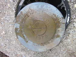
W.D. NO. 4 1975 |
| Stability:
|
Monument will probably hold position well |
| Setting:
|
Copper-clad steel rod without sleeve (10FT+ or 3.048M+) |
| Mark Condition:
|
G |
| Description:
|
This bench mark is located on Pawleys Island. It is at the "V" intersection formed by two roads, County Rd S-22-455 & County Rd S-22-48. It is 21.0 feet WNW of the centerline of County Rd S-22-48, 8.86 feet SW of a utility pole No. 61906 with two Guy Cables, and 3.28 feet NE of a Witness Post. The disk is crimped to a copper steel rod that protrudes 0.02 feet above the PVC pipe it was once encased in. It is a standard National Ocean Service brass disk stamped NO 4 1975. |
| Observed:
|
2015-09-21T12:37:00Z |
more obs 2001-03-31
|
| Source:
|
OPUS - page5 1209.04 |
|
|
|
| Close-up View
|
|
| REF_FRAME:
NAD_83(2011) |
EPOCH:
2010.0000 |
SOURCE:
NAVD88 (Computed using GEOID18) |
UNITS:
m |
SET PROFILE
|
DETAILS
|
|
| LAT:
|
33° 24' 44.59380"
|
± 0.002
m |
| LON:
|
-79° 7' 56.43703"
|
±
0.003
m |
| ELL HT:
|
-32.549 |
±
0.002
m |
| X:
|
1004810.831 |
±
0.003
m |
| Y:
|
-5233818.407 |
±
0.001
m |
| Z:
|
3492209.092 |
±
0.003
m |
| ORTHO HT:
|
2.273 |
±
0.054
m |
|
|
UTM
17 |
SPC
3900(SC) |
| NORTHING:
|
3698564.694m |
176681.230m |
| EASTING:
|
673664.720m |
783278.445m |
| CONVERGENCE:
|
1.02870339°
|
1.03542748°
|
| POINT SCALE:
|
0.99997184 |
0.99980366 |
| COMBINED FACTOR:
|
0.99997695 |
0.99980877 |
|
|
|
|
| Horizon View
|
|
|
|
|