| PID:
|
DD1345 |
| Designation:
|
866 2245 A TIDAL |
| Stamping:
|
2245 A 1982 |
| Stability:
|
Monument will probably hold position well |
| Setting:
|
Stainless steel rod without sleeve (10FT+ or 3.048M+) |
| Mark Condition:
|
G |
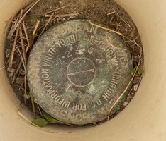
| Description:
|
The BM is a disk set near the Belle Baruch Institute lab boat landing on Crab Haul Creek, 8.11m (26.6ft) ENE of the north corner of a concrete boat landing, 4.45m (14.6ft) north of power pole # 70915 with a security light, 0.52m (1.7ft) SSE of power pole No. 0656 with three transformers, and 0.46m (1.5ft) ESE of a witness post. The BM is set 10cm (0.3ft) below ground level, crimped to the top of a stainless steel rod driven 11.3m (37ft) to refusal, and encased in a PVC pipe and conc. kickblock. |
| Observed:
|
2023-03-09T13:23:00Z |
more obs 2023-04-21
|
| Source:
|
OPUS - page5 2008.25 |
|
|
|
| Close-up View
|
|
| REF_FRAME:
NAD_83(2011) |
EPOCH:
2010.0000 |
SOURCE:
NAVD88 (Computed using GEOID18) |
UNITS:
m |
SET PROFILE
|
DETAILS
|
|
| LAT:
|
33° 21' 1.32512"
|
± 0.009
m |
| LON:
|
-79° 11' 25.99919"
|
±
0.012
m |
| ELL HT:
|
-33.867 |
±
0.004
m |
| X:
|
1000202.408 |
±
0.012
m |
| Y:
|
-5238553.003 |
±
0.006
m |
| Z:
|
3486464.571 |
±
0.006
m |
| ORTHO HT:
|
0.890 |
±
0.054
m |
|
|
UTM
17 |
SPC
3900(SC) |
| NORTHING:
|
3691591.777m |
169708.700m |
| EASTING:
|
668370.697m |
777986.146m |
| CONVERGENCE:
|
0.99498889°
|
1.00315556°
|
| POINT SCALE:
|
0.99994952 |
0.99980906 |
| COMBINED FACTOR:
|
0.99995484 |
0.99981438 |
|
|
|
|
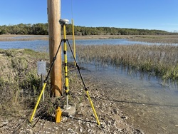
| Horizon View
|
|
|
|
|