| PID:
|
DD0924 |
| Designation:
|
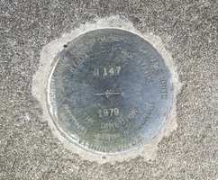
U 147 |
| Stamping:
|
U 147 1979 |
| Stability:
|
Monument will probably hold position well |
| Setting:
|
Massive structures (other than listed below) |
| Mark Condition:
|
G |
| Description:
|
The bench mark is a disk located on the SW corner of the U.S. Highway 17 Bridge over the Pee Dee and Black Rivers, 0.72 km (0.45 mi) west of the U.S. Highway 17 bridge over Waccamaw River, 11 m (35 ft) east of the SW end of the bridge, 9 m (29 ft) south of the centerline of U.S. Highway 17, 0.3 m (1 ft) north of the south concrete guard rail, and 0.3 m (1 ft) south of the north edge of the sidewalk. |
| Observed:
|
2023-02-08T14:13:00Z |
more obs 2023-03-27
|
| Source:
|
OPUS - page5 2008.25 |
|
|
|
| Close-up View
|
|
| REF_FRAME:
NAD_83(2011) |
EPOCH:
2010.0000 |
SOURCE:
NAVD88 (Computed using GEOID18) |
UNITS:
m |
SET PROFILE
|
DETAILS
|
|
| LAT:
|
33° 22' 1.11119"
|
± 0.019
m |
| LON:
|
-79° 16' 4.11510"
|
±
0.009
m |
| ELL HT:
|
-31.278 |
±
0.060
m |
| X:
|
992949.924 |
±
0.008
m |
| Y:
|
-5238903.870 |
±
0.061
m |
| Z:
|
3488004.443 |
±
0.019
m |
| ORTHO HT:
|
3.320 |
±
0.085
m |
|
|
UTM
17 |
SPC
3900(SC) |
| NORTHING:
|
3693311.102m |
171426.826m |
| EASTING:
|
661150.577m |
770766.706m |
| CONVERGENCE:
|
0.95290833°
|
0.96032500°
|
| POINT SCALE:
|
0.99992018 |
0.99980750 |
| COMBINED FACTOR:
|
0.99992509 |
0.99981241 |
|
|
|
|
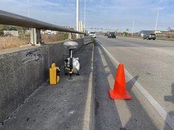
| Horizon View
|
|
|
|
|