| PID:
|
DD0885 |
| Designation:
|
H 137 |
| Stamping:
|
H 137 1979 |
| Stability:
|
Monument will probably hold position well |
| Setting:
|
Stainless steel rod without sleeve (10FT+ or 3.048M+) |
| Mark Condition:
|
G |
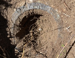
| Description:
|
The bench mark is a flange encased rod located near the Coast Guard maintenance garage, 29.11m (95.5ft) west of bench mark WB NO 1 1975, 27.83m (91.3ft) west of the NW corner of the pier, 19.63m (64.4ft) NNW of bench mark WB NO 2 1975, 12.13m (39.8ft) south of a gas pump, 4.02m (13.2ft) north of the NE corner of the garage, and 0.42m (1.4ft) south of a witness post. The datum point is the top of a stainless steel rod driven to a depth of 12.5m (41ft), and encased in a 5-inch NGS logo cap. |
| Observed:
|
2023-04-13T07:34:00Z |
more obs 2023-05-03
|
| Source:
|
OPUS - page5 2008.25 |
|
|
|
| Close-up View
|
|
| REF_FRAME:
NAD_83(2011) |
EPOCH:
2010.0000 |
SOURCE:
NAVD88 (Computed using GEOID18) |
UNITS:
m |
SET PROFILE
|
DETAILS
|
|
| LAT:
|
33° 14' 7.53162"
|
± 0.006
m |
| LON:
|
-79° 12' 16.30094"
|
±
0.008
m |
| ELL HT:
|
-33.724 |
±
0.007
m |
| X:
|
1000235.575 |
±
0.007
m |
| Y:
|
-5245670.760 |
±
0.004
m |
| Z:
|
3475808.757 |
±
0.009
m |
| ORTHO HT:
|
0.890 |
±
0.052
m |
|
|
UTM
17 |
SPC
3900(SC) |
| NORTHING:
|
3678823.622m |
156942.049m |
| EASTING:
|
667289.667m |
776907.408m |
| CONVERGENCE:
|
0.98429167°
|
0.99540833°
|
| POINT SCALE:
|
0.99994505 |
0.99982215 |
| COMBINED FACTOR:
|
0.99995034 |
0.99982744 |
|
|
|
|
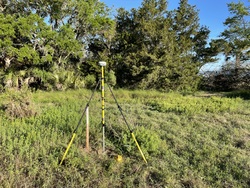
| Horizon View
|
|
|
|
|