| PID:
|
DD0822 |
| Designation:
|
866 0854 A TIDAL |
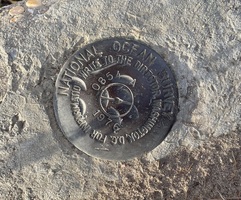
| Stamping:
|
0854 A 1976 |
| Stability:
|
Monuments of questionable or unknown reliability |
| Setting:
|
Pavement (street sidewalk curb etc.) |
| Mark Condition:
|
G |
| Description:
|
The primary bench mark is a disk set in the NE corner of the combination bridge curb, 16.15 m (53.0 ft) north of the center of the road, 11.06 m (36.3 ft) ENE of power pole #20864 with three guy wires and transformers, 3.44 m (11.3 ft) ENE of the center of the ramp, 0.37 m (1.2 ft) WNW of a witness post, and 0.21 m (0.3 ft) west of the south corner of the NE guardrail. |
| Observed:
|
2023-01-15T09:46:00Z |
more obs 2023-02-16
|
| Source:
|
OPUS - page5 2008.25 |
|
|
|
| Close-up View
|
|
| REF_FRAME:
NAD_83(2011) |
EPOCH:
2010.0000 |
SOURCE:
NAVD88 (Computed using GEOID18) |
UNITS:
m |
SET PROFILE
|
DETAILS
|
|
| LAT:
|
33° 42' 51.46182"
|
± 0.002
m |
| LON:
|
-78° 55' 16.32061"
|
±
0.008
m |
| ELL HT:
|
-28.006 |
±
0.018
m |
| X:
|
1020534.674 |
±
0.007
m |
| Y:
|
-5211915.836 |
±
0.014
m |
| Z:
|
3520114.455 |
±
0.011
m |
| ORTHO HT:
|
6.626 |
±
0.053
m |
|
|
UTM
17 |
SPC
3900(SC) |
| NORTHING:
|
3732418.434m |
210528.489m |
| EASTING:
|
692629.327m |
802237.359m |
| CONVERGENCE:
|
1.15419722°
|
1.15248611°
|
| POINT SCALE:
|
1.00005746 |
0.99979396 |
| COMBINED FACTOR:
|
1.00006186 |
0.99979836 |
|
|
|
|
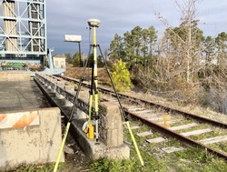
| Horizon View
|
|
|
|
|