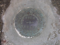
Shared Solution

PID: DD0688
Designation: V 124
Stamping: V 124 1962
Stability: Monument will probably hold position well
Setting: Abutment or pier of large bridges
Mark Condition: G
Description: Located 10.24 m west of the John T. Stevens Memorial Bridge Monument, 4.21 m West of the Centerline of U.S. Highway 17 South, 0.7 m SE of the SW bridge railing of the southbound lane, 0.3 m above road level, set flush in the concrete bridge abutment.
Observed: 2009-10-15T14:02:00Z more obs 2009-06-04 more obs Latest
Source: OPUS - page5 0909.08
Close-up View
REF_FRAME:   NAD_83(CORS96) EPOCH:   2002.0000 SOURCE:   NAVD88 (Computed using GEOID09) UNITS:  m  SET PROFILE   DETAILS
LAT: 33° 11' 2.34729" ±  0.005   m
LON: -79° 24' 21.54375" ±   0.015   m
ELL HT: -27.404 ±   0.044   m
X: 982360.697 ±   0.022  m
Y: -5252231.879 ±   0.034  m
Z: 3471038.924 ±   0.024  m
ORTHO HT: 6.528 ±  0.072   m
UTM  17 SPC  3900(SC )
NORTHING: 3672815.466m 150930.755m
EASTING: 648604.220m 758224.667m
CONVERGENCE: 0.87261141° 0.88372123°
POINT SCALE: 0.99987228 0.99982930
COMBINED FACTOR: 0.99987658 0.99983360
CONTRIBUTED BY
Stephen.Randall
National Geodetic Survey
Horizon View
The numerical values for this position solution have satisfied the quality control criteria of the National Geodetic Survey. The contributor has verified that the information submitted is accurate and complete.