| PID:
|
DD0688 |
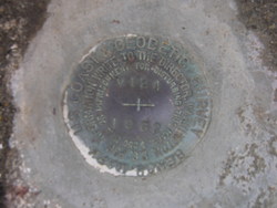
| Designation:
|
V 124 |
| Stamping:
|
V 124 1962 |
| Stability:
|
Monument will probably hold position well |
| Setting:
|
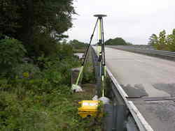
Abutment or pier of large bridges |
| Mark Condition:
|
G |
| Description:
|
Located 10.24 m west of the John T. Stevens Memorial Bridge Monument, 4.21 m West of the Centerline of U.S. Highway 17 South, 0.7 m SE of the SW bridge railing of the southbound lane, 0.3 m above road level, set flush in the concrete bridge abutment. |
| Observed:
|
2009-10-15T14:02:00Z |
more obs 2009-06-04
|
more obs Original
|
| Source:
|
OPUS - page5 1209.04 |
|
|
|
| Close-up View
|
|
| REF_FRAME:
NAD_83(2011) |
EPOCH:
2010.0000 |
SOURCE:
NAVD88 (Computed using GEOID18) |
UNITS:
m |
SET PROFILE
|
DETAILS
|
|
| LAT:
|
33° 11' 2.34697"
|
± 0.005
m |
| LON:
|
-79° 24' 21.54253"
|
±
0.004
m |
| ELL HT:
|
-27.431 |
±
0.017
m |
| X:
|
982360.725 |
±
0.006
m |
| Y:
|
-5252231.856 |
±
0.011
m |
| Z:
|
3471038.901 |
±
0.013
m |
| ORTHO HT:
|
6.544 |
±
0.052
m |
|
|
UTM
17 |
SPC
3900(SC) |
| NORTHING:
|
3672815.457m |
150930.746m |
| EASTING:
|
648604.252m |
758224.699m |
| CONVERGENCE:
|
0.87261160°
|
0.88372141°
|
| POINT SCALE:
|
0.99987228 |
0.99982930 |
| COMBINED FACTOR:
|
0.99987659 |
0.99983361 |
|
|
|
|
| Horizon View
|
|
|
|
|