| PID:
|
CK5864 |
| Designation:
|
BACK RM 1 |
| Stamping:
|
BACK NO 1 1934 |
| Stability:
|
Monument will probably hold position well |
| Setting:
|
Abutment or pier of large bridges |
| Mark Condition:
|
G |
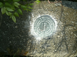
| Description:
|
The tidal bench mark is a Reference Mark disk set flush in the concrete bridge abutment on the NE corner of the U.S. Highway 17/Route 170 bridge over Little Back River, 6.55 m (21.5 ft) SW of the dirt canal dike on the east bank of Little Back River, 5.39 m (17.7 ft) north of the centerline of the bridge, 0.37 m (1.2 ft) north of the centerline of the bridge railing, 0.15 m (0.5 ft) south of the north edge of the bridge abutment, and 0.21 m (0.7 ft) above the road bed. |
| Observed:
|
2015-04-02T13:25:00Z |
more obs 2015- -
|
| Source:
|
OPUS - page5 1209.04 |
|
|
|
| Close-up View
|
|
| REF_FRAME:
NAD_83(2011) |
EPOCH:
2010.0000 |
SOURCE:
NAVD88 (Computed using GEOID18) |
UNITS:
m |
SET PROFILE
|
DETAILS
|
|
| LAT:
|
32° 9' 57.46954"
|
± 0.027
m |
| LON:
|
-81° 7' 29.09823"
|
±
0.024
m |
| ELL HT:
|
-27.778 |
±
0.017
m |
| X:
|
833788.721 |
±
0.022
m |
| Y:
|
-5339552.430 |
±
0.026
m |
| Z:
|
3376009.496 |
±
0.027
m |
| ORTHO HT:
|
3.424 |
±
0.053
m |
|
|
UTM
17 |
SPC
3900(SC) |
| NORTHING:
|
3558838.582m |
36899.358m |
| EASTING:
|
488238.012m |
597831.732m |
| CONVERGENCE:
|
-0.06641341°
|
-0.06916105°
|
| POINT SCALE:
|
0.99960171 |
1.00013432 |
| COMBINED FACTOR:
|
0.99960607 |
1.00013868 |
|
|
|
|
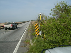
| Horizon View
|
|
|
|
|