| PID:
|
CK4294 |
| Designation:
|
10 329 |
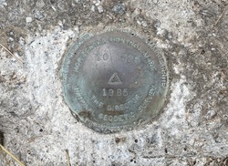
| Stamping:
|
10 329 1985 |
| Stability:
|
May hold commonly subject to ground movement |
| Setting:
|
Set in top of concrete monument |
| Mark Condition:
|
G |
| Description:
|
The mark is a brass disk set in a concrete post flush with the ground and 0.2 m (0.7 ft) below the road, 28.8 m (94.5 ft) north of the north corner of the NW one of two brick pillars for the gate, 26.8 m (87.9 ft) SE of a power pole number 314014, 22.2 m (72.8 ft) NW of the center of the field access road, 7.30 m (24.0 ft) NNW of the telephone junction box number 35, and 6.60 m (21.7 ft) SW of the center of the road. |
| Observed:
|
2023-07-27T12:55:00Z |
more obs 2023-08-24
|
| Source:
|
OPUS - page5 2008.25 |
|
|
|
| Close-up View
|
|
| REF_FRAME:
NAD_83(2011) |
EPOCH:
2010.0000 |
SOURCE:
NAVD88 (Computed using GEOID18) |
UNITS:
m |
SET PROFILE
|
DETAILS
|
|
| LAT:
|
32° 43' 57.54306"
|
± 0.019
m |
| LON:
|
-80° 11' 36.06130"
|
±
0.028
m |
| ELL HT:
|
-28.834 |
±
0.019
m |
| X:
|
914731.249 |
±
0.024
m |
| Y:
|
-5292067.174 |
±
0.028
m |
| Z:
|
3429039.238 |
±
0.010
m |
| ORTHO HT:
|
3.822 |
±
0.059
m |
|
|
UTM
17 |
SPC
3900(SC) |
| NORTHING:
|
3621936.924m |
100031.306m |
| EASTING:
|
575581.333m |
685204.182m |
| CONVERGENCE:
|
0.43619167°
|
0.44720556°
|
| POINT SCALE:
|
0.99967044 |
0.99992617 |
| COMBINED FACTOR:
|
0.99967497 |
0.99993070 |
|
|
|
|
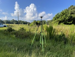
| Horizon View
|
|
|
|
|