| PID:
|
CK2678 |
| Designation:
|
866 7062 B TIDAL |
| Stamping:
|
7062 B 1977 |
| Stability:
|
Monument will probably hold position well |
| Setting:
|
Stainless steel rod without sleeve (10FT+ or 3.048M+) |
| Mark Condition:
|
G |
| Description:
|
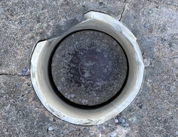
The primary bench mark is a disk located in the high marsh area north of the road leading to the bridge, 94.64 m (310.5 ft) NNW of the NE corner of the bridge, 34.78 m (114.1 ft) NE of the centerline of the road, and 0.58 m (1.9 ft) WSW of a metal witness post. The bench mark is set at ground level, crimped to the top of a galvanized steel rod driven 12.2 m (40 ft) to refusal, and encased in a PVC pipe and a concrete kickblock. |
| Observed:
|
2023-07-28T12:40:00Z |
more obs 2023-09-06
|
| Source:
|
OPUS - page5 2008.25 |
|
|
|
| Close-up View
|
|
| REF_FRAME:
NAD_83(2011) |
EPOCH:
2010.0000 |
SOURCE:
NAVD88 (Computed using GEOID18) |
UNITS:
m |
SET PROFILE
|
DETAILS
|
|
| LAT:
|
32° 36' 17.49431"
|
± 0.008
m |
| LON:
|
-80° 7' 58.12432"
|
±
0.015
m |
| ELL HT:
|
-31.778 |
±
0.039
m |
| X:
|
921632.735 |
±
0.009
m |
| Y:
|
-5298631.804 |
±
0.036
m |
| Z:
|
3417107.748 |
±
0.020
m |
| ORTHO HT:
|
1.049 |
±
0.070
m |
|
|
UTM
17 |
SPC
3900(SC) |
| NORTHING:
|
3607814.841m |
85906.657m |
| EASTING:
|
581369.541m |
690996.961m |
| CONVERGENCE:
|
0.46730278°
|
0.48076944°
|
| POINT SCALE:
|
0.99968164 |
0.99996472 |
| COMBINED FACTOR:
|
0.99968663 |
0.99996971 |
|
|
|
|
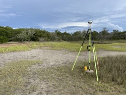
| Horizon View
|
|
|
|
|