| PID:
|
CK2454 |
| Designation:
|
866 6217 G TIDAL |
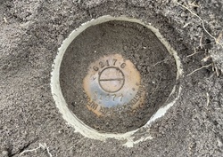
| Stamping:
|
6217 G 1977 |
| Stability:
|
Monument will probably hold position well |
| Setting:
|
Stainless steel rod without sleeve (10FT+ or 3.048M+) |
| Mark Condition:
|
G |
| Description:
|
The bench mark is a disk located near the bend in the paved road by power pole No. 77849, 12.80 m (42.0 ft) SW of a brick driveway marker, 4.94 m (16.2 ft) SE of power pole No. 77849, 4.27 m (14.0 ft) west of centerline of paved road, and 0.91 m (3.0 ft) west of the west side of paved road. The bench mark is crimped to the top of a copper-clad steel rod driven 9.8 m (32 ft) to refusal, encased in 4-inch PVC and concrete kickblock. |
| Observed:
|
2023-07-27T17:54:00Z |
more obs 2023-09-08
|
| Source:
|
OPUS - page5 2008.25 |
|
|
|
| Close-up View
|
|
| REF_FRAME:
NAD_83(2011) |
EPOCH:
2010.0000 |
SOURCE:
NAVD88 (Computed using GEOID18) |
UNITS:
m |
SET PROFILE
|
DETAILS
|
|
| LAT:
|
32° 41' 41.62398"
|
± 0.020
m |
| LON:
|
-80° 13' 32.76480"
|
±
0.022
m |
| ELL HT:
|
-28.794 |
±
0.045
m |
| X:
|
912121.041 |
±
0.021
m |
| Y:
|
-5294813.907 |
±
0.040
m |
| Z:
|
3425516.380 |
±
0.033
m |
| ORTHO HT:
|
3.812 |
±
0.074
m |
|
|
UTM
17 |
SPC
3900(SC) |
| NORTHING:
|
3617728.739m |
95821.432m |
| EASTING:
|
572574.359m |
682197.224m |
| CONVERGENCE:
|
0.41823056°
|
0.42923333°
|
| POINT SCALE:
|
0.99966495 |
0.99993705 |
| COMBINED FACTOR:
|
0.99966947 |
0.99994157 |
|
|
|
|
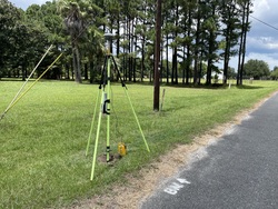
| Horizon View
|
|
|
|
|