| PID:
|
CJ0437 |
| Designation:
|
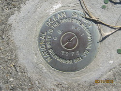
866 5424 TIDAL CD 1 |
| Stamping:
|
C.D. NO. 1 1975 |
| Stability:
|
Monument will probably hold position well |
| Setting:
|
Retaining wall or concrete ledge |
| Mark Condition:
|
G |
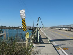
| Description:
|
The primary bench mark is a disk set flush in the concrete sidewalk at the SW end of the Folly Creek bridge, 5.18 m (17.0 ft) SW of the center-line of State
Highway 171, 4.72 m (15.5 ft) North of power pole #134598, 0.12 m (0.4 ft) NW of the end of the bridge, and 0.30 m (1.0 ft) above the highway. |
| Observed:
|
2015-02-11T14:58:00Z |
more obs 2013-04-15
|
| Source:
|
OPUS - page5 1209.04 |
|
|
|
| Close-up View
|
|
| REF_FRAME:
NAD_83(2011) |
EPOCH:
2010.0000 |
SOURCE:
NAVD88 (Computed using GEOID18) |
UNITS:
m |
SET PROFILE
|
DETAILS
|
|
| LAT:
|
32° 40' 29.40092"
|
± 0.005
m |
| LON:
|
-79° 57' 1.19149"
|
±
0.003
m |
| ELL HT:
|
-30.026 |
±
0.011
m |
| X:
|
937773.547 |
±
0.001
m |
| Y:
|
-5291549.916 |
±
0.009
m |
| Z:
|
3423643.172 |
±
0.010
m |
| ORTHO HT:
|
3.217 |
±
0.052
m |
|
|
UTM
17 |
SPC
3900(SC) |
| NORTHING:
|
3615726.630m |
93824.730m |
| EASTING:
|
598416.122m |
708045.884m |
| CONVERGENCE:
|
0.56673107°
|
0.58193583°
|
| POINT SCALE:
|
0.99971943 |
0.99994301 |
| COMBINED FACTOR:
|
0.99972414 |
0.99994772 |
|
|
|
|
| Horizon View
|
|
|
|
|