| PID:
|
CJ0435 |
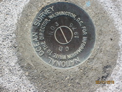
| Designation:
|
866 5424 TIDAL CD 3 |
| Stamping:
|
C.D. NO. 3 1975 |
| Stability:
|
Monument will probably hold position well |
| Setting:
|
Retaining wall or concrete ledge |
| Mark Condition:
|
G |
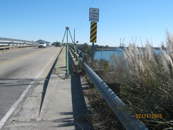
| Description:
|
The bench mark is a disk set flush in the concrete sidewalk at the NW end of the Folly Creek bridge, 238 m (780 ft) NW of bench mark CD No 1 1975, 4.75 m (15.6ft) SW of the center-line of State Highway 171, 0.21 m (0.7ft) SE of the end of the bridge, and 0.3 m (1.0 ft) above the highway. |
| Observed:
|
2015-02-11T14:46:00Z |
more obs 2013-09-24
|
| Source:
|
OPUS - page5 1209.04 |
|
|
|
| Close-up View
|
|
| REF_FRAME:
NAD_83(2011) |
EPOCH:
2010.0000 |
SOURCE:
NAVD88 (Computed using GEOID18) |
UNITS:
m |
SET PROFILE
|
DETAILS
|
|
| LAT:
|
32° 40' 34.80728"
|
± 0.005
m |
| LON:
|
-79° 57' 6.65726"
|
±
0.002
m |
| ELL HT:
|
-29.993 |
±
0.006
m |
| X:
|
937617.644 |
±
0.001
m |
| Y:
|
-5291486.257 |
±
0.006
m |
| Z:
|
3423783.376 |
±
0.006
m |
| ORTHO HT:
|
3.245 |
±
0.050
m |
|
|
UTM
17 |
SPC
3900(SC) |
| NORTHING:
|
3615891.712m |
93989.811m |
| EASTING:
|
598272.119m |
707901.806m |
| CONVERGENCE:
|
0.56593433°
|
0.58109410°
|
| POINT SCALE:
|
0.99971908 |
0.99994256 |
| COMBINED FACTOR:
|
0.99972379 |
0.99994727 |
|
|
|
|
| Horizon View
|
|
|
|
|