| PID:
|
CJ0326 |
| Designation:
|
PORT |
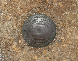
| Stamping:
|
PORT 1962 |
| Stability:
|
Monument will probably hold position well |
| Setting:
|
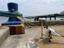
Abutment or pier of large bridges |
| Mark Condition:
|
G |
| Description:
|
The bench mark is a disk set flush on the SE edge of the passenger terminal pier of the South Carolina Port Authority, 3.08 m (10.1 ft) SSE of the SE corner of the 3x3 m (9x9 ft) concrete block building housing the U.S. Department of Commerce National Ocean Service Tide Station, 1.80 m (5.9 ft) NE of the SW edge of the pier, and 1.25 m (4.1 ft) NW of the SE edge of the pier. |
| Observed:
|
2023-05-22T19:01:00Z |
more obs 2017-12-07
|
| Source:
|
OPUS - page5 2008.25 |
|
|
|
| Close-up View
|
|
| REF_FRAME:
NAD_83(2011) |
EPOCH:
2010.0000 |
SOURCE:
NAVD88 (Computed using GEOID18) |
UNITS:
m |
SET PROFILE
|
DETAILS
|
|
| LAT:
|
32° 46' 50.80922"
|
± 0.017
m |
| LON:
|
-79° 55' 24.90737"
|
±
0.009
m |
| ELL HT:
|
-30.701 |
±
0.057
m |
| X:
|
939132.027 |
±
0.015
m |
| Y:
|
-5284856.716 |
±
0.055
m |
| Z:
|
3433526.970 |
±
0.016
m |
| ORTHO HT:
|
2.519 |
±
0.084
m |
|
|
UTM
17 |
SPC
3900(SC) |
| NORTHING:
|
3627497.375m |
105598.500m |
| EASTING:
|
600804.573m |
710431.833m |
| CONVERGENCE:
|
0.58284722°
|
0.59676389°
|
| POINT SCALE:
|
0.99972530 |
0.99991293 |
| COMBINED FACTOR:
|
0.99973012 |
0.99991775 |
|
|
|
|
| Horizon View
|
|
|
|
|