| PID:
|
CJ0167 |
| Designation:
|
PLEASANT |
| Stamping:
|
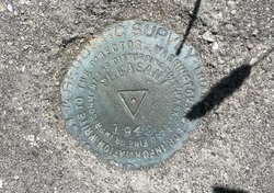
PLEASANT 1942 |
| Stability:
|
May hold commonly subject to ground movement |
| Setting:
|
Set in top of concrete monument |
| Mark Condition:
|
G |
| Description:
|
The bench mark is a disk set in the top of a concrete monument between the highway and the marsh, 20.97 m (68.8 ft) NNW of power pole #21418 with two guy wires and a street light, 20 m (66 ft) SSE of bench mark PLEASANT NO 1 1942, 10.03 m (32.9 ft) ENE of the centerline of the highway, 0.91 m (3.0 ft) WSW of a wooden post, and 0.12 m (0.4 ft) above the ground. |
| Observed:
|
2023-04-12T11:57:00Z |
more obs 2023-05-17
|
| Source:
|
OPUS - page5 2008.25 |
|
|
|
| Close-up View
|
|
| REF_FRAME:
NAD_83(2011) |
EPOCH:
2010.0000 |
SOURCE:
NAVD88 (Computed using GEOID18) |
UNITS:
m |
SET PROFILE
|
DETAILS
|
|
| LAT:
|
32° 47' 9.60281"
|
± 0.002
m |
| LON:
|
-79° 50' 59.24814"
|
±
0.005
m |
| ELL HT:
|
-31.815 |
±
0.013
m |
| X:
|
945882.480 |
±
0.006
m |
| Y:
|
-5283333.281 |
±
0.011
m |
| Z:
|
3434013.101 |
±
0.008
m |
| ORTHO HT:
|
1.554 |
±
0.053
m |
|
|
UTM
17 |
SPC
3900(SC) |
| NORTHING:
|
3628148.859m |
106251.829m |
| EASTING:
|
607709.372m |
717337.699m |
| CONVERGENCE:
|
0.62290000°
|
0.63767500°
|
| POINT SCALE:
|
0.99974305 |
0.99991153 |
| COMBINED FACTOR:
|
0.99974804 |
0.99991652 |
|
|
|

|
| Horizon View
|
|
|
|
|