| PID:
|
BH1905 |
| Designation:
|
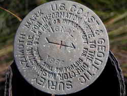
SIGNAL AZ MK |
| Stamping:
|
SIGNAL 1966 |
| Stability:
|
Monuments of questionable or unknown reliability |
| Setting:
|
A metal rod driven into ground. Describe below. |
| Mark Condition:
|
G |
| Description:
|
To reach the station from the NPS dock at the Fort Massachusetts on Ship Island, go south on the boardwalk about 900 mt to the station on the right.The disk projects 3 ft, located 13.1 mi SW from Gulf port,0.27 km (268m) 879 ft south from the south wall of the fort,40.0 ft WNW from the west edge of the boardwalk, 41.0 ft WSW from the southwest corner of the covered rain shelter attached to the boardwalk.
|
| Observed:
|
2009-02-03T16:09:00Z |
more obs 1986
|
more obs Original
|
| Source:
|
OPUS - page5 1209.04 |
|
|
|
| Close-up View
|
|
| REF_FRAME:
NAD_83(2011) |
EPOCH:
2010.0000 |
SOURCE:
NAVD88 (Computed using GEOID18) |
UNITS:
m |
SET PROFILE
|
DETAILS
|
|
| LAT:
|
30° 12' 34.71857"
|
± 0.002
m |
| LON:
|
-88° 58' 19.62113"
|
±
0.001
m |
| ELL HT:
|
-26.050 |
±
0.005
m |
| X:
|
98961.775 |
±
0.001
m |
| Y:
|
-5515689.661 |
±
0.005
m |
| Z:
|
3190465.690 |
±
0.002
m |
| ORTHO HT:
|
1.340 |
±
0.060
m |
|
|
UTM
16 |
SPC
2301(MS E) |
| NORTHING:
|
3343660.162m |
78668.257m |
| EASTING:
|
310176.305m |
286638.179m |
| CONVERGENCE:
|
-0.99259824°
|
-0.06983124°
|
| POINT SCALE:
|
1.00004456 |
0.99995220 |
| COMBINED FACTOR:
|
1.00004865 |
0.99995629 |
|
|
|
|
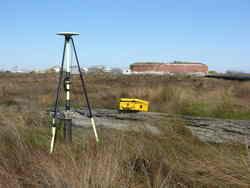
| Horizon View
|
|
|
|
|