| PID:
|
BH1752 |
| Designation:
|
873 5180 C TIDAL |
| Stamping:
|
5180 C 1976 |
| Stability:
|
Monuments of questionable or unknown reliability |
| Setting:
|
Pavement (street sidewalk curb etc.) |
| Mark Condition:
|
G |
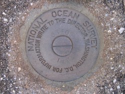
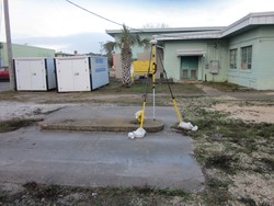
| Description:
|
The benchmark is set in top and near the north edge of a 16.4 ft x 19.7 ft concrete slab, 60.70 ft SSW of the SE corner of the east wing of the Administration Building, 12.04 ft north of the south edge of slab, 10.20 ft west of the east edge of slab, 9.97 ft east of the west edge of slab, and 2.59 ft south of the north edge of slab. It is a standard National Ocean Service brass disk stamped:
5180 C 1976. |
| Observed:
|
2018-01-12T13:58:00Z |
more obs 2010-03-09
|
| Source:
|
OPUS - page5 1603.24 |
|
|
|
| Close-up View
|
|
| REF_FRAME:
NAD_83(2011) |
EPOCH:
2010.0000 |
SOURCE:
NAVD88 (Computed using GEOID18) |
UNITS:
m |
SET PROFILE
|
DETAILS
|
|
| LAT:
|
30° 14' 58.04196"
|
± 0.010
m |
| LON:
|
-88° 4' 36.47039"
|
±
0.003
m |
| ELL HT:
|
-25.209 |
±
0.002
m |
| X:
|
185061.328 |
±
0.003
m |
| Y:
|
-5511249.905 |
±
0.004
m |
| Z:
|
3194279.358 |
±
0.009
m |
| ORTHO HT:
|
2.493 |
±
0.051
m |
|
|
UTM
16 |
SPC
102(AL W) |
| NORTHING:
|
3346918.078m |
27792.260m |
| EASTING:
|
396403.092m |
544489.924m |
| CONVERGENCE:
|
-0.54250203°
|
-0.29057819°
|
| POINT SCALE:
|
0.99973240 |
0.99997133 |
| COMBINED FACTOR:
|
0.99973636 |
0.99997529 |
|
|
|
|
| Horizon View
|
|
|
|
|