| PID:
|
BG4538 |
| Designation:
|
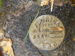
872 9793 D TIDAL |
| Stamping:
|
9793 D |
| Stability:
|
Monument will probably hold position well |
| Setting:
|
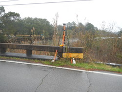
Massive structures (other than listed below) |
| Mark Condition:
|
G |
| Description:
|
The bench mark is a disk set in top of the concrete curbing, at the SE corner of the County Road C-281A (Montecito Boulevard) bridge over Mulatto Bayou, 275.0 Ft North of bench mark 9793 F 2015, 13.5 Ft E of the centerline of the road, and 0.5 FT above the level of the road. |
| Observed:
|
2020-02-01T17:33:00Z |
more obs 2020-02-12
|
| Source:
|
OPUS - page5 1801.18 |
|
|
|
| Close-up View
|
|
| REF_FRAME:
NAD_83(2011) |
EPOCH:
2010.0000 |
SOURCE:
NAVD88 (Computed using GEOID18) |
UNITS:
m |
SET PROFILE
|
DETAILS
|
|
| LAT:
|
30° 32' 54.45244"
|
± 0.012
m |
| LON:
|
-87° 6' 21.96576"
|
±
0.007
m |
| ELL HT:
|
-23.968 |
±
0.011
m |
| X:
|
277554.240 |
±
0.008
m |
| Y:
|
-5490573.308 |
±
0.015
m |
| Z:
|
3222870.080 |
±
0.005
m |
| ORTHO HT:
|
3.445 |
±
0.051
m |
|
|
UTM
16 |
SPC
903(FL N) |
| NORTHING:
|
3379566.386m |
174502.618m |
| EASTING:
|
489823.482m |
349970.305m |
| CONVERGENCE:
|
-0.05392778°
|
-1.30963333°
|
| POINT SCALE:
|
0.99960128 |
0.99997048 |
| COMBINED FACTOR:
|
0.99960504 |
0.99997424 |
|
|
|
|
| Horizon View
|
|
|
|
|