| PID:
|
BG3643 |
| Designation:
|
872 9974 C TIDAL |
| Stamping:
|
9974 C 1977 |
| Stability:
|
Monument will probably hold position well |
| Setting:
|
Copper-clad steel rod without sleeve (10FT+ or 3.048M+) |
| Mark Condition:
|
G |
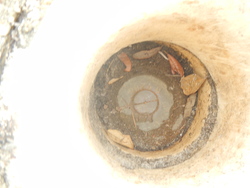
| Description:
|
The bench mark is a disk located 300 Ft SW of bench mark 9974 B 1977, 86.5 Ft ENE of the SE corner of 14642 River Rd , 18.4 Ft NW of the centerline of the paved road, and 22.2 Ft SW 2 Ft high concrete wall. The bench mark is set 0.3 ft below paved driveway, crimped to the top of a copper-clad steel rod driven an unspecified depth to refusal, and encased in a PVC pipe and concrete. |
| Observed:
|
2020-01-20T17:39:00Z |
more obs 2020-01-31
|
| Source:
|
OPUS - page5 1801.18 |
|
|
|
| Close-up View
|
|
| REF_FRAME:
NAD_83(2011) |
EPOCH:
2010.0000 |
SOURCE:
NAVD88 (Computed using GEOID18) |
UNITS:
m |
SET PROFILE
|
DETAILS
|
|
| LAT:
|
30° 17' 52.26713"
|
± 0.008
m |
| LON:
|
-87° 26' 56.01941"
|
±
0.007
m |
| ELL HT:
|
-25.883 |
±
0.023
m |
| X:
|
245326.247 |
±
0.007
m |
| Y:
|
-5506188.355 |
±
0.024
m |
| Z:
|
3198912.383 |
±
0.005
m |
| ORTHO HT:
|
1.611 |
±
0.059
m |
|
|
UTM
16 |
SPC
903(FL N) |
| NORTHING:
|
3351875.821m |
147532.001m |
| EASTING:
|
456834.841m |
316371.194m |
| CONVERGENCE:
|
-0.22646944°
|
-1.48189444°
|
| POINT SCALE:
|
0.99962299 |
0.99995102 |
| COMBINED FACTOR:
|
0.99962705 |
0.99995508 |
|
|
|
|
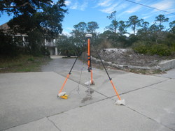
| Horizon View
|
|
|
|
|