| PID:
|
BG3615 |
| Designation:
|
872 9905 B TIDAL |
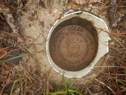
| Stamping:
|
9905 B 1977 |
| Stability:
|
Monument will probably hold position well |
| Setting:
|
Copper-clad steel rod without sleeve (10FT+ or 3.048M+) |
| Mark Condition:
|
G |
| Description:
|
The primary bench mark is located in the SE corner of an empty grassy lot, SW of 10024 Lillian Highway (Rt 298) 250.0 Ft South of Perdido Bay mean high water mark, 69 Ft NE of the centerline of the driveway To the empty lot, 39 Ft ENE of a metal sign frame (No sign) 30.35 Ft NW of the centerline of Lillian Highway, and 7.8 Ft SW of a power pole with a light. The bench mark is set 0.3 Ft below ground level, crimped to the top of a copper-clad steel rod. |
| Observed:
|
2020-01-16T18:42:00Z |
more obs 2020-01-29
|
| Source:
|
OPUS - page5 1801.18 |
|
|
|
| Close-up View
|
|
| REF_FRAME:
NAD_83(2011) |
EPOCH:
2010.0000 |
SOURCE:
NAVD88 (Computed using GEOID18) |
UNITS:
m |
SET PROFILE
|
DETAILS
|
|
| LAT:
|
30° 25' 6.23824"
|
± 0.023
m |
| LON:
|
-87° 21' 19.80353"
|
±
0.015
m |
| ELL HT:
|
-26.088 |
±
0.047
m |
| X:
|
253989.486 |
±
0.013
m |
| Y:
|
-5499034.131 |
±
0.050
m |
| Z:
|
3210443.559 |
±
0.021
m |
| ORTHO HT:
|
1.471 |
±
0.076
m |
|
|
UTM
16 |
SPC
903(FL N) |
| NORTHING:
|
3365202.516m |
160662.266m |
| EASTING:
|
465857.389m |
325686.626m |
| CONVERGENCE:
|
-0.17999444°
|
-1.43496389°
|
| POINT SCALE:
|
0.99961438 |
0.99995800 |
| COMBINED FACTOR:
|
0.99961848 |
0.99996210 |
|
|
|
|
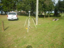
| Horizon View
|
|
|
|
|