| PID:
|
BC1572 |
| Designation:
|
STJO 204 |
| Stamping:
|
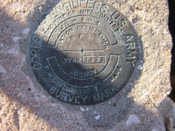
STJO 204 1973 RPS JAX FLA |
| Stability:
|
Monument will probably hold position well |
| Setting:
|
Massive structures (other than listed below) |
| Mark Condition:
|
G |
| Description:
|
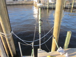
Contact must be made prior to obtaining access to this bench mark from Mr. Matthew Staley of the Army Corp Of Engineers. The bench mark is a disk set in a concrete bulkhead in the north east corner of a boat slip, 56.7 ft southeast of the north west corner of a chain link fence, 34.0 ft southwest of the northwest end of the boat slip, and 5.3 ft south of a chain link fence. It is a Army Corp Of Engineers brass survey disk stamped: STJO 204 1973 RPS JAX FLA. |
| Observed:
|
2016-05-06T11:48:00Z |
more obs 1977
|
| Source:
|
OPUS - page5 1209.04 |
|
|
|
| Close-up View
|
|
| REF_FRAME:
NAD_83(2011) |
EPOCH:
2010.0000 |
SOURCE:
NAVD88 (Computed using GEOID18) |
UNITS:
m |
SET PROFILE
|
DETAILS
|
|
| LAT:
|
30° 21' 26.86056"
|
± 0.005
m |
| LON:
|
-81° 37' 12.35481"
|
±
0.008
m |
| ELL HT:
|
-27.256 |
±
0.049
m |
| X:
|
802759.475 |
±
0.009
m |
| Y:
|
-5449503.515 |
±
0.044
m |
| Z:
|
3204615.516 |
±
0.021
m |
| ORTHO HT:
|
1.051 |
±
0.078
m |
|
|
UTM
17 |
SPC
901(FL E) |
| NORTHING:
|
3358559.017m |
667654.836m |
| EASTING:
|
440407.861m |
140387.522m |
| CONVERGENCE:
|
-0.31340288°
|
-0.31340288°
|
| POINT SCALE:
|
0.99964381 |
0.99998500 |
| COMBINED FACTOR:
|
0.99964809 |
0.99998928 |
|
|
|
|
| Horizon View
|
|
|
|
|