| PID:
|
BBJC48 |
| Designation:
|
866 5763 B |
| Stamping:
|
5763 B 2022 |
| Stability:
|
Monument will probably hold position well |
| Setting:
|
Stainless steel rod in sleeve (10FT+ or 3.048M+) |
| Mark Condition:
|
G |
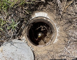
| Description:
|
The mark is in the grass clearing north of the main house and to the SE of the main two-track road, located 57.2 m (187.7 ft) NE of a utility pole with a flood light and two guy wires, 50.0 m (164.0 ft) west of a 1.5 m (5 ft) tall wood post in the NE corner of the clearing, 35.7 m (117.1 ft) SW of the trunk of a 12.2 m (40.0 ft) tall black gum tree, and 24.1 m (79.1 ft) SE of the approximate centerline of the two-track road. |
| Observed:
|
2023-07-27T13:09:00Z |
more obs 2023-08-24
|
| Source:
|
OPUS - page5 2008.25 |
|
|
|
| Close-up View
|
|
| REF_FRAME:
NAD_83(2011) |
EPOCH:
2010.0000 |
SOURCE:
NAVD88 (Computed using GEOID18) |
UNITS:
m |
SET PROFILE
|
DETAILS
|
|
| LAT:
|
32° 44' 22.41647"
|
± 0.023
m |
| LON:
|
-80° 10' 32.73884"
|
±
0.033
m |
| ELL HT:
|
-25.438 |
±
0.036
m |
| X:
|
916285.636 |
±
0.032
m |
| Y:
|
-5291380.640 |
±
0.030
m |
| Z:
|
3429685.608 |
±
0.038
m |
| ORTHO HT:
|
7.252 |
±
0.068
m |
|
|
UTM
17 |
SPC
3900(SC) |
| NORTHING:
|
3622715.573m |
100810.470m |
| EASTING:
|
577223.525m |
686846.640m |
| CONVERGENCE:
|
0.44578889°
|
0.45695833°
|
| POINT SCALE:
|
0.99967353 |
0.99992423 |
| COMBINED FACTOR:
|
0.99967752 |
0.99992822 |
|
|
|
|
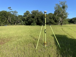
| Horizon View
|
|
|
|
|