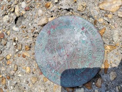
Shared Solution

PID: BBHW28
Designation: 876 1927 E
Stamping: 1927 E 2005
Stability: May hold, commonly subject to ground movement
Setting: Retaining wall or concrete ledge
Description: THE BENCH MARK IS SET IN THE SEA WALL ALONG LAKE PONCHATRAIN, 27.25 M (89.40 FT) WNW OF LIGHT POLE "HU8," 24.74 M (81.17 FT) FROM THE CENTERLINE OF LAKESHORE DRIVE, 22.6 M (74.1 FT) WEST-NORTHWEST OF AN ALUMINUM LIGHT POLE W/ CONCRETE AND 0.15 M (0.5 FT) SOUTH OF THE NORTH EDGE OF THE CONCRETE SEAWALL BEING A BRASS DISK SET IN THE CONCRETE CAP.
Observed: 2022-06-11T16:56:00Z
Source: OPUS - page5 2008.25
Close-up View
REF_FRAME:   NAD_83(2011) EPOCH:   2010.0000 SOURCE:   NAVD88 (Computed using GEOID18) UNITS:  m  SET PROFILE   DETAILS
LAT: 30° 1' 38.31427" ±  0.011   m
LON: -90° 6' 37.42420" ±   0.002   m
ELL HT: -24.324 ±   0.023   m
X: -10648.697 ±   0.002  m
Y: -5526711.030 ±   0.024  m
Z: 3172982.950 ±   0.007  m
ORTHO HT: 1.823 ±  0.076   m
UTM  15 SPC  1702(LA S)
NORTHING: 3325329.918m 169922.951m
EASTING: 778678.714m 1117953.404m
CONVERGENCE: 1.44692778° 0.61148333°
POINT SCALE: 1.00055828 0.99992585
COMBINED FACTOR: 1.00056210 0.99992967
CONTRIBUTED BY
brett.gregory
National Oceanic and Atmospheric Administration
Horizon View
The numerical values for this position solution have satisfied the quality control criteria of the National Geodetic Survey. The contributor has verified that the information submitted is accurate and complete.