| PID:
|
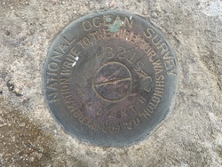
BBHV16 |
| Designation:
|
865 3215 C |
| Stamping:
|
3215 C RODANTHE |
| Stability:
|
May hold, commonly subject to ground movement |
| Setting:
|
Set in top of concrete monument |
| Mark Condition:
|
G |
| Description:
|
The bench mark is a disk set in the top of an 8-inch concrete post located SE of the intersection of State Highway 12 and Myrna Peters Road, 37.7 m (123.7 ft) west of the SW corner of the westernmost of three storage garages, 31.9 m (104.7 ft) SSW of Laura Lane, 16.7 m (54.8 ft) east of the centerline for State Highway 12, 1.3 m (4.4 ft) NNE of the southernmost spotlight for a historic site and museum sign, and 0.15 m (0.5 ft) above ground. |
| Observed:
|
2022-04-13T13:06:00Z |
more obs 2022-05-06
|
| Source:
|
OPUS - page5 2008.25 |
|
|
|
| Close-up View
|
|