Shared Solution

PID: BBHG48
Designation: 872 0357 G
Stamping: 0357 G 2021
Stability: Monument will probably hold position well
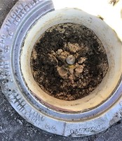
Setting: Stainless steel rod in sleeve (10FT+ or 3.048M+)
Description: A stainless steel rod driven to refusal in the island between feeder lanes from I-295 Beltway westbound, 17.4 meters West of the US-17 North sign, 24.85 meters East of the Wrong Way sign, 9.6 meters South of the edge of I-295-to-17 North feeder lane, 0.2 meters East of a carsonite NOS witness post.
Observed: 2021-02-23T22:17:00Z
Source: OPUS - page5 2008.25
Close-up View
REF_FRAME:   NAD_83(2011) EPOCH:   2010.0000 SOURCE:   NAVD88 (Computed using GEOID18) UNITS:  m  SET PROFILE   DETAILS
LAT: 30° 11' 36.17318" ±  0.002   m
LON: -81° 42' 19.08234" ±   0.001   m
ELL HT: -20.882 ±   0.008   m
X: 795978.610 ±   0.002  m
Y: -5459771.042 ±   0.007  m
Z: 3188910.200 ±   0.004  m
ORTHO HT: 7.304 ±  0.041   m
UTM  17 SPC  901(FL E)
NORTHING: 3340424.063m 649513.693m
EASTING: 432106.807m 132083.634m
CONVERGENCE: -0.35472222° -0.35472222°
POINT SCALE: 0.99965687 0.99999806
COMBINED FACTOR: 0.99966015 1.00000134
CONTRIBUTED BY
kris.kirby
Center for Operational Oceanographic Products and Services
Horizon View
The numerical values for this position solution have satisfied the quality control criteria of the National Geodetic Survey. The contributor has verified that the information submitted is accurate and complete.