| PID:
|
BBGR81 |
| Designation:
|
874 7437 K |
| Stamping:
|
7437 K 2010 |
| Stability:
|
Monument will probably hold position well |
| Setting:
|
Stainless steel rod in sleeve (10FT+ or 3.048M+) |
| Description:
|
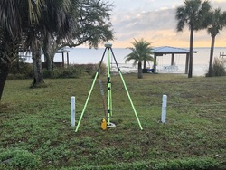
Mark is located 735.8 ft SE of the center of entrance to Bay Waveland Yacht Club on NE side of road, 56.8 ft SW of the SW corner of covered picnic area on beach, 41.3 ft NW of the southern-most flag pole, 6.8 ft NE of the edge of pavement, and 3.0 ft SE of the northern end wooden brace for rope fence. |
| Observed:
|
2020-01-04T13:51:00Z |
| Source:
|
OPUS - page5 1801.18 |
|
|

|
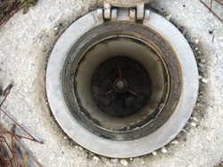
| Close-up View
|
|
| REF_FRAME:
NAD_83(2011) |
EPOCH:
2010.0000 |
SOURCE:
NAVD88 (Computed using GEOID18) |
UNITS:
m |
SET PROFILE
|
DETAILS
|
|
| LAT:
|
30° 19' 20.40881"
|
± 0.005
m |
| LON:
|
-89° 19' 33.34685"
|
±
0.011
m |
| ELL HT:
|
-24.700 |
±
0.011
m |
| X:
|
64825.576 |
±
0.011
m |
| Y:
|
-5509900.740 |
±
0.009
m |
| Z:
|
3201256.172 |
±
0.007
m |
| ORTHO HT:
|
2.766 |
±
0.056
m |
|
|
UTM
16 |
SPC
2301(MS E) |
| NORTHING:
|
3356796.113m |
91254.962m |
| EASTING:
|
276367.654m |
252627.643m |
| CONVERGENCE:
|
-1.17476667°
|
-0.24870000°
|
| POINT SCALE:
|
1.00021703 |
0.99997768 |
| COMBINED FACTOR:
|
1.00022091 |
0.99998156 |
|
|
|

|
| Horizon View
|
|
|
|
|