| PID:
|
BBGR64 |
| Designation:
|
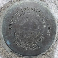
941 7426 C USCG |
| Stamping:
|
7426C USCG |
| Stability:
|
Monument will probably hold position well |
| Setting:
|
Massive retaining walls |
| Description:
|
The benchmark is 4" disk located on the USCG Noyo River facility, 1.98 m(6.50 ft) E of the W most flag pole, 17.2 m(56.43 ft) W of the W corner of the USCG building, 49.93 m(163.81 ft) NWN of the N side of the entrance gate, and 3.12 m(10.24 ft) NW of the NW corner of USCG parking lot. The benchmark is set in a concrete walkway. Special use permit or authorization is required to access the benchmark. |
| Observed:
|
2019-12-20T16:20:00Z |
| Source:
|
OPUS - page5 1801.18 |
|
|
|
| Close-up View
|
|