| PID:
|
BBGN52 |
| Designation:
|
946 5265 D |
| Stamping:
|
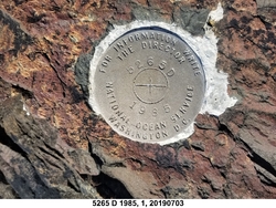
5265 D 1985 |
| Stability:
|
Most reliable; expected to hold position well |
| Setting:
|
In rock outcrop or ledge |
| Description:
|
The bench mark is a disk set in bedrock at Kulukak Point, located on a rock projection pointing south, 24.3 m (79.7 ft) ENE of the highest point of a tidal rock island on which bench mark 946 5265 A is set, 20.4 m (66.9 ft) West of the edge of grassy vegetation, 16.8 m (55.1 ft) east of bench mark 946 5265 B, and 15.91 m (52.2 f) SE of bench mark 946 5265 C. |
| Observed:
|
2019-07-03T20:23:00Z |
| Source:
|
OPUS - page5 1603.24 |
|
|
|
| Close-up View
|
|
| REF_FRAME:
NAD_83(2011) |
EPOCH:
2010.0000 |
SOURCE:
NAVD88 (Computed using GEOID12B) |
UNITS:
m |
SET PROFILE
|
DETAILS
|
|
| LAT:
|
58° 50' 21.90073"
|
± 0.006
m |
| LON:
|
-159° 39' 0.39474"
|
±
0.006
m |
| ELL HT:
|
18.161 |
±
0.016
m |
| X:
|
-3101931.306 |
±
0.012
m |
| Y:
|
-1150510.822 |
±
0.009
m |
| Z:
|
5434717.292 |
±
0.011
m |
| ORTHO HT:
|
4.543 |
±
0.020
m |
|
|
UTM
4 |
SPC
5006(AK 6) |
| NORTHING:
|
6522353.389m |
539985.239m |
| EASTING:
|
462476.313m |
404733.880m |
| CONVERGENCE:
|
-0.55631944°
|
-1.41213889°
|
| POINT SCALE:
|
0.99961726 |
1.00001121 |
| COMBINED FACTOR:
|
0.99961442 |
1.00000837 |
|
|
|

|
| Horizon View
|
|
|
|
|