| PID:
|
BBGK47 |
| Designation:
|
975 1364 F |
| Stamping:
|
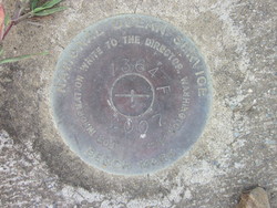
1364 F 2007 |
| Stability:
|
May hold, commonly subject to ground movement |
| Setting:
|
Pavement (street, sidewalk, curb, etc.) |
| Description:
|
The bench mark is a disk set flush in top of a concrete median strip, located at the corner of Lobster Street and Green Street, 124.02 ft west of the centerline of Fort Street, 101.7 ft SE of the eastern-most entrance of the parking lot along the shoreline, and 28.54 ft north of the centerline of Green Street. It is a standard National Ocean Service disk set flush in the sidewalk stamped: 1364 F 2007. |
| Observed:
|
2019-04-16T14:58:00Z |
| Source:
|
OPUS - page5 1603.24 |
|
|
|
| Close-up View
|
|
| REF_FRAME:
NAD_83(2011) |
EPOCH:
2010.0000 |
SOURCE:
H = h-N (N = GEOID18 HGT) |
UNITS:
m |
SET PROFILE
|
DETAILS
|
|
| LAT:
|
17° 44' 45.09060"
|
± 0.022
m |
| LON:
|
-64° 41' 52.04310"
|
±
0.038
m |
| ELL HT:
|
-40.018 |
±
0.054
m |
| X:
|
2597053.318 |
±
0.037
m |
| Y:
|
-5493560.266 |
±
0.053
m |
| Z:
|
1931601.662 |
±
0.034
m |
| ORTHO HT:
|
1.273 |
±
0.091
m |
|
|
UTM
20 |
SPC
5200(PRVI) |
| NORTHING:
|
1962881.748m |
191190.500m |
| EASTING:
|
319990.230m |
384066.952m |
| CONVERGENCE:
|
-0.51761944°
|
0.54303056°
|
| POINT SCALE:
|
1.00000064 |
1.00002989 |
| COMBINED FACTOR:
|
1.00000693 |
1.00003618 |
|
|
|
|
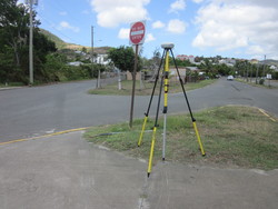
| Horizon View
|
|
|
|
|