| PID:
|
BBGF92 |
| Designation:
|
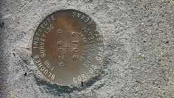
877 5296 D |
| Stamping:
|
5296 D 2012 |
| Stability:
|
Monument will probably hold position well |
| Setting:
|
Pavement (street, sidewalk, curb, etc.) |
| Mark Condition:
|
G |
| Description:
|
THIS IS A SURFACE MARK SET INTO THE CONCRETE CURB OF THE WALKWAY LEADING TO THE USS LEXINGTON. IT IS 39.7 M (130.2 FT) NORTH WEST OF 5296 C 2012, 11.4 M (37.4 FT) SOUTH OF THE A4 SKYHAWK DISPLAY, AND 36.9 M (121.1 FT) EAST OF THE ROAD CENTERLINE. |
| Observed:
|
2018-12-01T15:24:00Z |
more obs 2018-12-04
|
| Source:
|
OPUS - page5 1603.24 |
|
|
|
| Close-up View
|
|