Shared Solution

PID: BBGF89
Designation: 877 5792 F
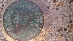
Stamping: 5792 F 2006
Stability: Monument will probably hold position well
Setting: Mat foundation or concrete slab other than pavement
Description: The bench mark is a disk set flush in concrete slab adjacent to SE wall of Billings Bait & Tackle shop, 99 feet W of the SW piling of the tide station next to the boat ramp, 16.5 feet SW of the concrete bulkhead perpendicular to the boat ramp, 12.7 feet NE of the southerly corner of Billings Bait & Tackle shop, and 11.6 feet SE of the northeasterly corner of Billings Bait & Tackle shop.
Observed: 2018-11-29T23:54:00Z
Source: OPUS - page5 1603.24
Close-up View
REF_FRAME:   NAD_83(2011) EPOCH:   2010.0000 SOURCE:   NAVD88 (Computed using GEOID18) UNITS:  m  SET PROFILE   DETAILS
LAT: 27° 38' 3.02773" ±  0.015   m
LON: -97° 14' 10.98564" ±   0.012   m
ELL HT: -25.154 ±   0.007   m
X: -712273.656 ±   0.012  m
Y: -5609575.849 ±   0.012  m
Z: 2940638.824 ±   0.011  m
ORTHO HT: 0.901 ±  0.050   m
UTM  14 SPC  4205(TX S)
NORTHING: 3057921.422m 5218612.186m
EASTING: 674000.926m 424701.142m
CONVERGENCE: 0.81821389° 0.57368889°
POINT SCALE: 0.99997372 0.99995563
COMBINED FACTOR: 0.99997767 0.99995958
CONTRIBUTED BY
joshua.d.witmer
National Oceanic and Atmospheric Administration
Horizon View
The numerical values for this position solution have satisfied the quality control criteria of the National Geodetic Survey. The contributor has verified that the information submitted is accurate and complete.