| PID:
|
BBGC92 |
| Designation:
|
877 0971 A |
| Stamping:
|
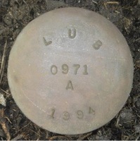
LUB 0971 A 1994 |
| Stability:
|
Monument will probably hold position well |
| Setting:
|
Stainless steel rod in sleeve (10FT+ or 3.048M+) |
| Mark Condition:
|
G |
| Description:
|
The primary bench mark is a brass disk crimped to a stainless steel rod, driven approx 55.1 ft to refusal, and encased in a 6-inch PVC pipe with concrete kickblock. The mark is located 271.7 FT NNW of LUB 0971 C 1994, 108.89 ft SW from the inshore edge of the pier to the tide station, 53 ft NE from the N corner of the house at lot 1765, 1.80 ft E of a wood utility pole, 9-inches SE of an orange witness post, and 4-inches below ground level.
Note - The mark received a datum point this visit. |
| Observed:
|
2018-09-07T15:54:00Z |
more obs 2018-09-19
|
| Source:
|
OPUS - page5 1603.24 |
|
|
|
| Close-up View
|
|
| REF_FRAME:
NAD_83(2011) |
EPOCH:
2010.0000 |
SOURCE:
NAVD88 (Computed using GEOID18) |
UNITS:
m |
SET PROFILE
|
DETAILS
|
|
| LAT:
|
29° 30' 55.11989"
|
± 0.011
m |
| LON:
|
-94° 30' 39.65990"
|
±
0.008
m |
| ELL HT:
|
-25.543 |
±
0.014
m |
| X:
|
-436897.269 |
±
0.009
m |
| Y:
|
-5537692.971 |
±
0.017
m |
| Z:
|
3123719.156 |
±
0.005
m |
| ORTHO HT:
|
1.257 |
±
0.074
m |
|
|
UTM
15 |
SPC
4204(TXSC) |
| NORTHING:
|
3266031.350m |
4194758.168m |
| EASTING:
|
353554.172m |
1035050.337m |
| CONVERGENCE:
|
-0.74454444°
|
2.19920833°
|
| POINT SCALE:
|
0.99986463 |
0.99986818 |
| COMBINED FACTOR:
|
0.99986864 |
0.99987219 |
|
|
|
|
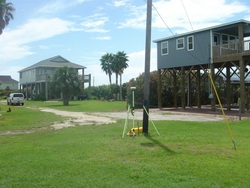
| Horizon View
|
|
|
|
|