| PID:
|
BBFY25 |
| Designation:
|
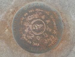
876 8094 A |
| Stamping:
|
8094 A 2002 |
| Stability:
|
Monument will probably hold position well |
| Setting:
|
Mat foundation or concrete slab other than pavement |
| Description:
|
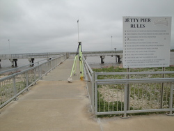
The bench mark is a disk set flush in the concrete pier at the shore end and on the N. side of the pier concrete walkway, know as the Jetty Fishing Pier Facility, 98.1 feet E of the W face or the offshore end of the fishing pier, 59.1 feet S of the NW corner of the concrete parking area for the fishing pier, 10.2 feet W of the E edge of the walkway leading to the pier, 8.2 feet N of the S face of the pier, and 0.98 feet S of the N face of the pier. |
| Observed:
|
2018-04-09T14:38:00Z |
| Source:
|
OPUS - page5 1603.24 |
|
|

|
| Close-up View
|
|
| REF_FRAME:
NAD_83(2011) |
EPOCH:
2010.0000 |
SOURCE:
NAVD88 (Computed using GEOID18) |
UNITS:
m |
SET PROFILE
|
DETAILS
|
|
| LAT:
|
29° 45' 50.94688"
|
± 0.004
m |
| LON:
|
-93° 20' 33.47711"
|
±
0.010
m |
| ELL HT:
|
-25.103 |
±
0.010
m |
| X:
|
-323093.453 |
±
0.011
m |
| Y:
|
-5531832.846 |
±
0.010
m |
| Z:
|
3147693.179 |
±
0.004
m |
| ORTHO HT:
|
1.380 |
±
0.076
m |
|
|
UTM
15 |
SPC
1702(LA S) |
| NORTHING:
|
3292701.109m |
141828.003m |
| EASTING:
|
466875.924m |
805696.151m |
| CONVERGENCE:
|
-0.17009494°
|
-1.00467510°
|
| POINT SCALE:
|
0.99961354 |
0.99993423 |
| COMBINED FACTOR:
|
0.99961748 |
0.99993817 |
|
|
|

|
| Horizon View
|
|
|
|
|