| PID:
|
BBFY03 |
| Designation:
|
876 7816 TIDAL 7 |
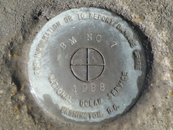
| Stamping:
|
BM NO 7 1988 |
| Stability:
|
Monument will probably hold position well |
| Setting:
|
Massive retaining walls |
| Mark Condition:
|
G |
| Description:
|
The bench mark is a disk set flush in the S. section of the Civic Center Park, 679.8' W. of the intersection of Lakeshore Dr. and Bord Du Lac Dr. 58' S. of the S. curb of the parking area, 32' SW. of an electric box, 7' W. of the centerline of the wooden walkway leading to the pier, and 1.25' N. of the S. face of the sea wall. |
| Observed:
|
2018-04-04T12:51:00Z |
more obs 2018-04-05
|
| Source:
|
OPUS - page5 1603.24 |
|
|
|
| Close-up View
|
|
| REF_FRAME:
NAD_83(2011) |
EPOCH:
2010.0000 |
SOURCE:
NAVD88 (Computed using GEOID18) |
UNITS:
m |
SET PROFILE
|
DETAILS
|
|
| LAT:
|
30° 13' 28.60997"
|
± 0.012
m |
| LON:
|
-93° 13' 21.35320"
|
±
0.011
m |
| ELL HT:
|
-25.502 |
±
0.018
m |
| X:
|
-310069.112 |
±
0.011
m |
| Y:
|
-5507020.447 |
±
0.016
m |
| Z:
|
3191899.972 |
±
0.014
m |
| ORTHO HT:
|
1.683 |
±
0.062
m |
|
|
UTM
15 |
SPC
1702(LA S) |
| NORTHING:
|
3343695.762m |
192663.245m |
| EASTING:
|
478579.413m |
818144.141m |
| CONVERGENCE:
|
-0.11205435°
|
-0.94465636°
|
| POINT SCALE:
|
0.99960566 |
0.99993334 |
| COMBINED FACTOR:
|
0.99960966 |
0.99993734 |
|
|
|
|
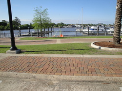
| Horizon View
|
|
|
|
|