| PID:
|
BBFX72 |
| Designation:
|
BASS |
| Stamping:
|
BASS 2014 |
| Stability:
|
Monuments of questionable or unknown reliability |
| Setting:
|
Object surrounded by mass of concrete |
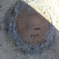
| Description:
|
Bass 2014 is a USACE brass disk set flush in the NW corner of a concrete pad that anchors the float system on the south side of the paved public boat ramp at Bass Harbor in Tremont, ME. The Ramp is located at the east end of Rice rd. The station is 29.23' south of REF 1, a 1/4" dh in a chiseled sq on the north concrete pad, 11.18' west of the NE corner of the south concrete pad, 20.02' NW of REF 2 a 1/4" dh in a chiseled sq in a concrete wall and 5.02' NE of a 4' high concrete filled steel Post |
| Observed:
|
2014-09-11T11:02:00Z |
| Source:
|
OPUS - page5 1603.24 |
|
|
|
| Close-up View
|
|