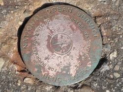
| PID:
|
BBFX22 |
| Designation:
|
876 1927 D |
| Stamping:
|
1927 D 2005 |
| Stability:
|
Monument will probably hold position well |
| Setting:
|
Massive retaining walls |
| Mark Condition:
|
G |
| Description:
|
The bench mark is a disk set in the top of the concrete seawall along Lake Pontchartrain. Due South of the Jetty Point, 119.7' North of Lakeshore Drive, 27.5' East-Northeast of a 2' round steel manhole cover cast "DRAIN", 20.7' East of a SS pipe guard railing around a large drain pipe, 15.3' West-Northwest of a 2' round steel manhole cover cast "DRAIN", and 8" S. of the N. edge of the seawall. |
| Observed:
|
2018-03-02T15:10:00Z |
more obs 2018-03-12
|
| Source:
|
OPUS - page5 1603.24 |
|
|
|
| Close-up View
|
|
| REF_FRAME:
NAD_83(2011) |
EPOCH:
2010.0000 |
SOURCE:
NAVD88 (Computed using GEOID18) |
UNITS:
m |
SET PROFILE
|
DETAILS
|
|
| LAT:
|
30° 1' 37.09920"
|
± 0.010
m |
| LON:
|
-90° 6' 43.18092"
|
±
0.006
m |
| ELL HT:
|
-24.374 |
±
0.013
m |
| X:
|
-10802.981 |
±
0.006
m |
| Y:
|
-5526729.410 |
±
0.006
m |
| Z:
|
3172950.531 |
±
0.015
m |
| ORTHO HT:
|
1.772 |
±
0.071
m |
|
|
UTM
15 |
SPC
1702(LA S) |
| NORTHING:
|
3325288.598m |
169883.896m |
| EASTING:
|
778525.374m |
1117799.575m |
| CONVERGENCE:
|
1.44611185°
|
0.61068482°
|
| POINT SCALE:
|
1.00055722 |
0.99992585 |
| COMBINED FACTOR:
|
1.00056105 |
0.99992968 |
|
|
|
|
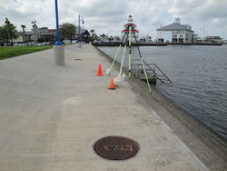
| Horizon View
|
|
|
|
|