| PID:
|
BBFX14 |
| Designation:
|
876 1955 C |
| Stamping:
|
1955 C 2009 |
| Stability:
|
Monument will probably hold position well |
| Setting:
|
Stainless steel rod in sleeve (10FT+ or 3.048M+) |
| Mark Condition:
|
G |
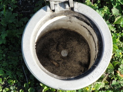
| Description:
|
The BM. is a flange-encased rod located 57.7' NNW. of the N. face of the USACE monument at the S. Ent. to the USACE property, 24.0' W. of the C/L of the W. RR. track outside the E. side of the USACE property, 10.8' E. of the chain link fence along the East side of the property, 6.6' S. of PP (TE887) with W/P, and the datum point is about level with the ground, being the top of a SS. rod driven 71.9' to refusal, in a sleeve extending 3.28' encased in a 5" PVC pipe with NGS logo |
| Observed:
|
2018-03-06T14:22:00Z |
more obs 2018-03-07
|
| Source:
|
OPUS - page5 1603.24 |
|
|
|
| Close-up View
|
|
| REF_FRAME:
NAD_83(2011) |
EPOCH:
2010.0000 |
SOURCE:
NAVD88 (Computed using GEOID18) |
UNITS:
m |
SET PROFILE
|
DETAILS
|
|
| LAT:
|
29° 56' 3.49854"
|
± 0.009
m |
| LON:
|
-90° 8' 2.03320"
|
±
0.008
m |
| ELL HT:
|
-22.676 |
±
0.028
m |
| X:
|
-12927.774 |
±
0.008
m |
| Y:
|
-5531859.465 |
±
0.027
m |
| Z:
|
3164053.592 |
±
0.013
m |
| ORTHO HT:
|
3.244 |
±
0.083
m |
|
|
UTM
15 |
SPC
1702(LA S) |
| NORTHING:
|
3314960.765m |
159590.588m |
| EASTING:
|
776669.124m |
1115794.557m |
| CONVERGENCE:
|
1.43111412°
|
0.59973283°
|
| POINT SCALE:
|
1.00054452 |
0.99992642 |
| COMBINED FACTOR:
|
1.00054808 |
0.99992998 |
|
|
|
|
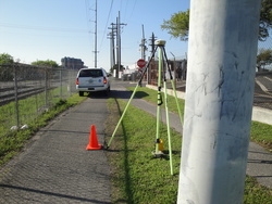
| Horizon View
|
|
|
|
|