| PID:
|
BBFX11 |
| Designation:
|
941 0032 TIDAL 6 |
| Stamping:
|
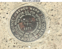
TIDAL 6 1971 |
| Stability:
|
Monument will probably hold position well |
| Setting:
|
Retaining wall or concrete ledge |
| Description:
|
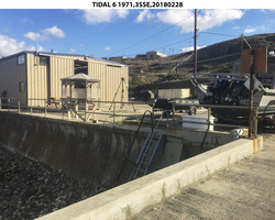
The mark is set in the top of a 1.2 m (3.9 ft) wide concrete seawall on the east side of the concrete pier, 16.56 m (54.3 ft) north of power pole D2-4-1, 15.07 m (49.4 ft) WNW of the NW corner of building 60177, 7.51 m (24.6 ft) south of the light pole closest to land on the east side of the pier, 5.62 m (18.4 ft) ESE of the east edge of the concrete vehicle ramp, 2.20 m (7.2 ft) ESE of the east side of the metal stairs to the beach, and 0.50 m (1.6 ft) SSW of the seaward edge of the seawall. |
| Observed:
|
2018-02-28T23:45:00Z |
| Source:
|
OPUS - page5 1603.24 |
|
|
|
| Close-up View
|
|
| REF_FRAME:
NAD_83(2011) |
EPOCH:
2010.0000 |
SOURCE:
NAVD88 (Computed using GEOID18) |
UNITS:
m |
SET PROFILE
|
DETAILS
|
|
| LAT:
|
33° 0' 17.42580"
|
± 0.014
m |
| LON:
|
-118° 33' 26.75736"
|
±
0.008
m |
| ELL HT:
|
-31.818 |
±
0.011
m |
| X:
|
-2559497.574 |
±
0.004
m |
| Y:
|
-4702760.410 |
±
0.017
m |
| Z:
|
3454391.524 |
±
0.006
m |
| ORTHO HT:
|
5.358 |
±
0.077
m |
|
|
UTM
11 |
SPC
405(CA 5) |
| NORTHING:
|
3652900.808m |
445212.388m |
| EASTING:
|
354511.738m |
1947889.380m |
| CONVERGENCE:
|
-0.84849800°
|
-0.31774321°
|
| POINT SCALE:
|
0.99986099 |
1.00038133 |
| COMBINED FACTOR:
|
0.99986598 |
1.00038633 |
|
|
|
|
| Horizon View
|
|
|
|
|