| PID:
|
BBFX10 |
| Designation:
|
941 0032 B |
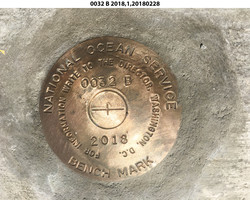
| Stamping:
|
0032 B 2018 |
| Stability:
|
Monument will probably hold position well |
| Setting:
|
Massive structures (other than listed below) |
| Description:
|
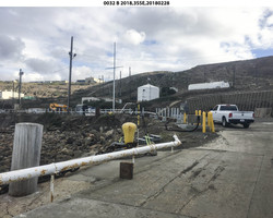
The mark is a NOS disk set in the circular concrete base of a large steel bollard, 26.39 m (86.6 ft) NW of a flagpole, 14.37 m (47.1 ft) east of a second steel bollard, 6.35 m (20.8 ft) north of the NE corner of a concrete catch basin for a fuel line box, 5.22 m (17.1 ft) SSW of a large concrete post on the east side of the barge landing, 1.72 m (5.6 ft) east of a 30 degree bend in a 0.17 m (0.6 ft) diameter elevated fuel pipe, and 0.14 m (0.5 ft) south of the edge of the square steel base. |
| Observed:
|
2018-02-28T00:10:00Z |
| Source:
|
OPUS - page5 1603.24 |
|
|
|
| Close-up View
|
|
| REF_FRAME:
NAD_83(2011) |
EPOCH:
2010.0000 |
SOURCE:
NAVD88 (Computed using GEOID18) |
UNITS:
m |
SET PROFILE
|
DETAILS
|
|
| LAT:
|
33° 0' 18.63288"
|
± 0.015
m |
| LON:
|
-118° 33' 29.03483"
|
±
0.006
m |
| ELL HT:
|
-33.358 |
±
0.007
m |
| X:
|
-2559539.198 |
±
0.005
m |
| Y:
|
-4702713.224 |
±
0.014
m |
| Z:
|
3454421.870 |
±
0.010
m |
| ORTHO HT:
|
3.817 |
±
0.079
m |
|
|
UTM
11 |
SPC
405(CA 5) |
| NORTHING:
|
3652938.861m |
445249.916m |
| EASTING:
|
354453.185m |
1947830.446m |
| CONVERGENCE:
|
-0.84885043°
|
-0.31810382°
|
| POINT SCALE:
|
0.99986120 |
1.00038115 |
| COMBINED FACTOR:
|
0.99986644 |
1.00038639 |
|
|
|
|
| Horizon View
|
|
|
|
|