| PID:
|
BBFW66 |
| Designation:
|
874 7437 M |
| Stamping:
|
7437 M 2010 |
| Stability:
|
Monument will probably hold position well |
| Setting:
|
Stainless steel rod in sleeve (10FT+ or 3.048M+) |
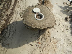
| Description:
|
The mark is a flange-encased rod located in a small beach where marsh meets seawall N of the Yacht club. 107.5 ft SE of a dock, 66 ft E of a phone pole, 28.5 ft NE of the CL of North Beach BLVD, and 11.5 ft NE of the top step of the seawall. The datum point is the top of a stainless steel rod with sleeve, driven 89.7 ft to refusal, encased in concrete with a 5-inch National Geodetic Survey logo cap, and 1.5 ft above ground.
Note - The concrete around the mark has been disturbed due to erosion. |
| Observed:
|
2018-02-09T15:58:00Z |
| Source:
|
OPUS - page5 1603.24 |
|
|
|
| Close-up View
|
|
| REF_FRAME:
NAD_83(2011) |
EPOCH:
2010.0000 |
SOURCE:
NAVD88 (Computed using GEOID18) |
UNITS:
m |
SET PROFILE
|
DETAILS
|
|
| LAT:
|
30° 19' 31.30007"
|
± 0.013
m |
| LON:
|
-89° 19' 44.28613"
|
±
0.013
m |
| ELL HT:
|
-26.755 |
±
0.021
m |
| X:
|
64531.354 |
±
0.013
m |
| Y:
|
-5509733.078 |
±
0.021
m |
| Z:
|
3201544.633 |
±
0.013
m |
| ORTHO HT:
|
0.716 |
±
0.057
m |
|
|
UTM
16 |
SPC
2301(MS E) |
| NORTHING:
|
3357137.497m |
91591.608m |
| EASTING:
|
276082.299m |
252336.877m |
| CONVERGENCE:
|
-1.17640885°
|
-0.25025568°
|
| POINT SCALE:
|
1.00021860 |
0.99997802 |
| COMBINED FACTOR:
|
1.00022280 |
0.99998222 |
|
|
|
|
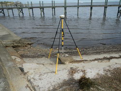
| Horizon View
|
|
|
|
|