| PID:
|
BBFW32 |
| Designation:
|
TAW |
| Stamping:
|
TAW |
| Stability:
|
Most reliable; expected to hold position well |
| Setting:
|
Object surrounded by mass of concrete |
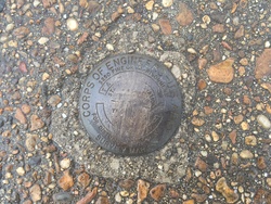
| Description:
|
Mark is disk located on Coast Guard Sector Mobile. It is on road to the wharf, by the wing wall. 99.5 ft NE of the base flag pole, 97.4 ft SE of the front door to the training building, 28.9 ft N of the intersection of wing wall and road and 24.8 ft W of the southern most light pole on the wharf. |
| Observed:
|
2018-01-27T15:31:00Z |
| Source:
|
OPUS - page5 1603.24 |
|
|
|
| Close-up View
|
|
| REF_FRAME:
NAD_83(2011) |
EPOCH:
2010.0000 |
SOURCE:
NAVD88 (Computed using GEOID18) |
UNITS:
m |
SET PROFILE
|
DETAILS
|
|
| LAT:
|
30° 39' 2.51536"
|
± 0.008
m |
| LON:
|
-88° 3' 34.76405"
|
±
0.002
m |
| ELL HT:
|
-24.846 |
±
0.022
m |
| X:
|
185946.809 |
±
0.002
m |
| Y:
|
-5488664.859 |
±
0.020
m |
| Z:
|
3232625.769 |
±
0.011
m |
| ORTHO HT:
|
3.589 |
±
0.059
m |
|
|
UTM
16 |
SPC
102(AL W) |
| NORTHING:
|
3391370.302m |
72263.874m |
| EASTING:
|
398469.093m |
546359.732m |
| CONVERGENCE:
|
-0.54026227°
|
-0.28532139°
|
| POINT SCALE:
|
0.99972716 |
0.99996881 |
| COMBINED FACTOR:
|
0.99973106 |
0.99997271 |
|
|
|
|
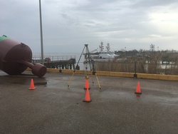
| Horizon View
|
|
|
|
|