| PID:
|
BBFT71 |
| Designation:
|
943 7954 D |
| Stamping:
|
7954 D 2017 |
| Stability:
|
May hold, commonly subject to ground movement |
| Setting:
|
Stainless steel rod in sleeve (10FT+ or 3.048M+) |
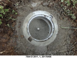
| Description:
|
The bench mark is a stainless-steel rod in sleeve, set on the east side of Northfork Rd near the boundary between address 38205 and an empty lot to the south, driven 42 ft (12.8 m) to refusal, encased in PVC with NOS logo cap and kick block with magnetic material, 32.60 m (107.0 ft) SSW of a fire hydrant, 9.33 m (30.6 ft) east of the centerline of Northfork Rd, 6.58 m (21.6 ft) south of a utility pole number 243503 on the east side of the road. The datum point is set 5 cm (2 inches) below grade. |
| Observed:
|
2017-06-10T22:08:00Z |
| Source:
|
OPUS - page5 1603.24 |
|
|
|
| Close-up View
|
|
| REF_FRAME:
NAD_83(2011) |
EPOCH:
2010.0000 |
SOURCE:
NAVD88 (Computed using GEOID18) |
UNITS:
m |
SET PROFILE
|
DETAILS
|
|
| LAT:
|
45° 44' 0.04124"
|
± 0.011
m |
| LON:
|
-123° 52' 38.27899"
|
±
0.003
m |
| ELL HT:
|
-16.886 |
±
0.009
m |
| X:
|
-2485842.445 |
±
0.010
m |
| Y:
|
-3702491.688 |
±
0.009
m |
| Z:
|
4544597.360 |
±
0.003
m |
| ORTHO HT:
|
5.458 |
±
0.050
m |
|
|
UTM
10 |
SPC
3601(OR N) |
| NORTHING:
|
5064795.188m |
235150.511m |
| EASTING:
|
431743.134m |
2237220.836m |
| CONVERGENCE:
|
-0.62825767°
|
-2.39513374°
|
| POINT SCALE:
|
0.99965728 |
0.99994314 |
| COMBINED FACTOR:
|
0.99965993 |
0.99994579 |
|
|
|
|
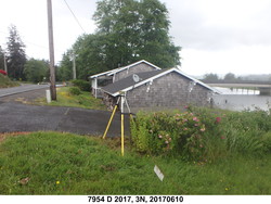
| Horizon View
|
|
|
|
|