| PID:
|
BBFR87 |
| Designation:
|
946 1710 J |
| Stamping:
|
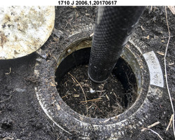
1710 J 2006 |
| Stability:
|
Monument will probably hold position well |
| Setting:
|
Stainless steel rod without sleeve (10FT+ or 3.048M+) |
| Description:
|
The station is a stainless steel rod driven 2.8 m (9.3 ft) to refusal and encased in an aluminum NGS Geodetic Control Mark logo cover, 168 m (551 ft) WSW of bench mark 946 1710 H, 165 m (541 ft) east of bench mark 946 1710 K, 30.51 m (100.1 ft) WSW of the south corner of a bridge on the single lane gravel road which ends at the dock, 7.50 m (24.6 ft) SSE of the SE edge of the gravel road, 4.11 m (13.5 ft) SE of the centerline of an ATV trail, and 1 m (3 ft) below the top of the gravel road. |
| Observed:
|
2017-06-17T21:59:00Z |
| Source:
|
OPUS - page5 1603.24 |
|
|
|
| Close-up View
|
|
| REF_FRAME:
NAD_83(2011) |
EPOCH:
2010.0000 |
SOURCE:
NAVD88 (Computed using GEOID12B) |
UNITS:
m |
SET PROFILE
|
DETAILS
|
|
| LAT:
|
52° 14' 2.36864"
|
± 0.012
m |
| LON:
|
-174° 11' 1.24717"
|
±
0.008
m |
| ELL HT:
|
10.226 |
±
0.006
m |
| X:
|
-3894265.442 |
±
0.012
m |
| Y:
|
-396685.785 |
±
0.010
m |
| Z:
|
5018798.921 |
±
0.003
m |
| ORTHO HT:
|
2.007 |
±
0.012
m |
|
|
UTM
1 |
SPC
5010(AK10) |
| NORTHING:
|
5790801.602m |
138873.635m |
| EASTING:
|
692312.929m |
1124064.614m |
| CONVERGENCE:
|
2.22703089°
|
1.44746626°
|
| POINT SCALE:
|
1.00005402 |
0.99990308 |
| COMBINED FACTOR:
|
1.00005242 |
0.99990148 |
|
|
|
|
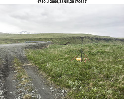
| Horizon View
|
|
|
|
|