| PID:
|
BBFR86 |
| Designation:
|
946 1710 H |
| Stamping:
|
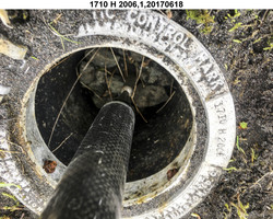
1710 H 2006 |
| Stability:
|
Monument will probably hold position well |
| Setting:
|
Stainless steel rod without sleeve (10FT+ or 3.048M+) |
| Description:
|
The station is a stainless steel rod driven 4.9 m (16.0 ft) to refusal and encased in an aluminum NGS Geodetic Control Mark logo cover, 168 m (551 ft) WSW of bench mark 946 1710 G, 168 m (551 ft) ENE of bench mark 946 1710 J, 16.00 m (52.5 ft) NNE from the north corner of a bridge on the single lane gravel road which ends at the dock, 9.69 m (31.8 ft) NNW from the west edge of the gravel road, and 6.49 m (21.3 ft) ENE from the centerline of an ATV trail. |
| Observed:
|
2017-06-18T03:28:00Z |
| Source:
|
OPUS - page5 1603.24 |
|
|
|
| Close-up View
|
|
| REF_FRAME:
NAD_83(2011) |
EPOCH:
2010.0000 |
SOURCE:
NAVD88 (Computed using GEOID12B) |
UNITS:
m |
SET PROFILE
|
DETAILS
|
|
| LAT:
|
52° 14' 4.57886"
|
± 0.009
m |
| LON:
|
-174° 10' 53.18490"
|
±
0.008
m |
| ELL HT:
|
11.318 |
±
0.007
m |
| X:
|
-3894196.873 |
±
0.011
m |
| Y:
|
-396832.593 |
±
0.009
m |
| Z:
|
5018841.623 |
±
0.003
m |
| ORTHO HT:
|
3.097 |
±
0.014
m |
|
|
UTM
1 |
SPC
5010(AK10) |
| NORTHING:
|
5790875.817m |
138945.789m |
| EASTING:
|
692463.168m |
1124215.825m |
| CONVERGENCE:
|
2.22882138°
|
1.44925098°
|
| POINT SCALE:
|
1.00005473 |
0.99990297 |
| COMBINED FACTOR:
|
1.00005296 |
0.99990120 |
|
|
|
|
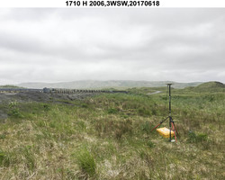
| Horizon View
|
|
|
|
|