| PID:
|
BBFR77 |
| Designation:
|
946 2620 TIDAL 10 |
| Stamping:
|
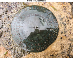
NO 10 1948 |
| Stability:
|
May hold, commonly subject to ground movement |
| Setting:
|
Mat foundation or concrete slab other than pavement |
| Description:
|
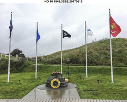
The bench mark is a disk set in the South side of the 3.30 m (10.8 ft) diameter concrete foundation of a three-stepped base for a wood pole (now gone) in the City of Unalaska Memorial Park, 17.20 m (56.4 ft) SE of a marble monument dedicated to lost mariners, 17.20 m (56.4 ft) West of a hexagonal concrete machine gun bunker, and 15.80 m (51.8 ft) SW of a marble square World War II in the Aleutians monument. |
| Observed:
|
2017-06-15T20:19:00Z |
| Source:
|
OPUS - page5 1603.24 |
|
|
|
| Close-up View
|
|
| REF_FRAME:
NAD_83(2011) |
EPOCH:
2010.0000 |
SOURCE:
NAVD88 (Computed using GEOID12B) |
UNITS:
m |
SET PROFILE
|
DETAILS
|
|
| LAT:
|
53° 52' 21.66154"
|
± 0.007
m |
| LON:
|
-166° 31' 26.32613"
|
±
0.005
m |
| ELL HT:
|
22.071 |
±
0.011
m |
| X:
|
-3664922.096 |
±
0.008
m |
| Y:
|
-878247.858 |
±
0.007
m |
| Z:
|
5128419.550 |
±
0.009
m |
| ORTHO HT:
|
5.836 |
±
0.019
m |
|
|
UTM
3 |
SPC
5010(AK10) |
| NORTHING:
|
5970432.963m |
360668.221m |
| EASTING:
|
399802.866m |
1621496.534m |
| CONVERGENCE:
|
-1.23103339°
|
7.55165292°
|
| POINT SCALE:
|
0.99972319 |
1.00001229 |
| COMBINED FACTOR:
|
0.99971973 |
1.00000883 |
|
|
|
|
| Horizon View
|
|
|
|
|