| PID:
|
BBFR67 |
| Designation:
|
946 2620 R |
| Stamping:
|
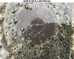
2620 R 2014 |
| Stability:
|
May hold, commonly subject to ground movement |
| Setting:
|
Mat foundation or concrete slab other than pavement |
| Description:
|
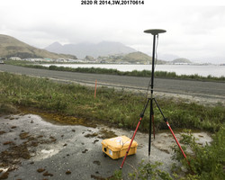
The bench mark is a disk set in the NE corner of a 3.3 m x 10.9 m (10.8 ft x 35.8 ft) concrete foundation, 29.25 m (96.0 ft) SW of a 1.22 m (4.0 ft) high yellow wooden bollard the western most of a group of three yellow bollards, 6.78 m (22.2 ft) south from the top of a 0.44 m (1.4 ft) diameter culvert with orange flag which runs beneath the road, 5.51 m (18.1 ft) E from an orange Carsonite survey marker post, and 0.82 m (2.7 ft) SW from the NE edge of the concrete. |
| Observed:
|
2017-06-15T01:45:00Z |
| Source:
|
OPUS - page5 1603.24 |
|
|

|
| Close-up View
|
|
| REF_FRAME:
NAD_83(2011) |
EPOCH:
2010.0000 |
SOURCE:
NAVD88 (Computed using GEOID12B) |
UNITS:
m |
SET PROFILE
|
DETAILS
|
|
| LAT:
|
53° 52' 26.27353"
|
± 0.010
m |
| LON:
|
-166° 31' 13.78056"
|
±
0.008
m |
| ELL HT:
|
19.721 |
±
0.012
m |
| X:
|
-3664755.324 |
±
0.005
m |
| Y:
|
-878443.597 |
±
0.009
m |
| Z:
|
5128501.720 |
±
0.015
m |
| ORTHO HT:
|
3.488 |
±
0.021
m |
|
|
UTM
3 |
SPC
5010(AK10) |
| NORTHING:
|
5970570.564m |
360839.706m |
| EASTING:
|
400035.026m |
1621705.022m |
| CONVERGENCE:
|
-1.22823796°
|
7.55443009°
|
| POINT SCALE:
|
0.99972262 |
1.00001270 |
| COMBINED FACTOR:
|
0.99971953 |
1.00000961 |
|
|
|

|
| Horizon View
|
|
|
|
|