| PID:
|
BBFR57 |
| Designation:
|
943 6641 B |
| Stamping:
|
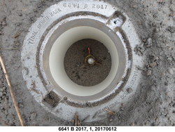
6641 B 2017 |
| Stability:
|
Monument will probably hold position well |
| Setting:
|
Stainless steel rod in sleeve (10FT+ or 3.048M+) |
| Description:
|
The station is a stainless-steel rod with sleeve set NW of a gravel access road just west of the US 101 bridge over the Little Nestucca River, driven 42.0 ft to refusal, encased in a NOS logo cover with kick block and magnetic material, 23.47 m (77.0 ft) NNW of the edge of pavement of US 101, 11.79 m (38.7 ft) west of a white sign reading S.H.R.W, 10.08 m (33.1 ft) NW of a utility pole numbered 053203, and 0.40 m (1.3 ft) SSE of a witness post. The datum point is set 5 cm (2 inches) below grade. |
| Observed:
|
2017-06-12T21:21:00Z |
| Source:
|
OPUS - page5 1603.24 |
|
|
|
| Close-up View
|
|
| REF_FRAME:
NAD_83(2011) |
EPOCH:
2010.0000 |
SOURCE:
NAVD88 (Computed using GEOID18) |
UNITS:
m |
SET PROFILE
|
DETAILS
|
|
| LAT:
|
45° 9' 39.09683"
|
± 0.003
m |
| LON:
|
-123° 56' 25.11884"
|
±
0.002
m |
| ELL HT:
|
-20.687 |
±
0.003
m |
| X:
|
-2515225.862 |
±
0.001
m |
| Y:
|
-3737368.325 |
±
0.002
m |
| Z:
|
4499956.881 |
±
0.004
m |
| ORTHO HT:
|
2.074 |
±
0.049
m |
|
|
UTM
10 |
SPC
3601(OR N) |
| NORTHING:
|
5001250.219m |
171794.508m |
| EASTING:
|
426096.804m |
2229612.712m |
| CONVERGENCE:
|
-0.66679431°
|
-2.43982031°
|
| POINT SCALE:
|
0.99966715 |
0.99989459 |
| COMBINED FACTOR:
|
0.99967039 |
0.99989783 |
|
|
|
|
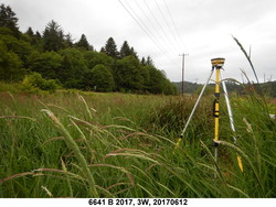
| Horizon View
|
|
|
|
|