| PID:
|
BBFP76 |
| Designation:
|
943 4068 B |
| Stamping:
|
4068 B 2017 |
| Stability:
|
Monument will probably hold position well |
| Setting:
|
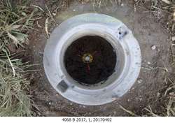
Stainless steel rod in sleeve (10FT+ or 3.048M+) |
| Description:
|
The station is a stainless-steel rod set at the SW corner of Rose Hill Road and Highway 126, driven 25 ft to refusal, encased in a NOS logo cover containing magnets with kick block, 29.51 m (96.8 ft) ENE of the SE corner of a metal building, 12.26 m (40.2 ft) NNE of the Southern post of the Siuslaw River RV park sign, 8.62 m (28.3 ft) west of a utility pole numbered 114212 and 6.41 m (21.0 ft) west of a 6' by 6' end post to a fence. The datum point is set 10 cm (4 in) below grade. |
| Observed:
|
2017-04-02T15:13:00Z |
| Source:
|
OPUS - page5 1209.04 |
|
|
|
| Close-up View
|
|
| REF_FRAME:
NAD_83(2011) |
EPOCH:
2010.0000 |
SOURCE:
NAVD88 (Computed using GEOID18) |
UNITS:
m |
SET PROFILE
|
DETAILS
|
|
| LAT:
|
43° 58' 56.35320"
|
± 0.009
m |
| LON:
|
-124° 3' 9.41239"
|
±
0.005
m |
| ELL HT:
|
-20.604 |
±
0.015
m |
| X:
|
-2574010.923 |
±
0.005
m |
| Y:
|
-3808579.298 |
±
0.015
m |
| Z:
|
4406664.005 |
±
0.006
m |
| ORTHO HT:
|
3.758 |
±
0.056
m |
|
|
UTM
10 |
SPC
3602(OR S) |
| NORTHING:
|
4870447.729m |
263283.800m |
| EASTING:
|
415582.332m |
1215060.455m |
| CONVERGENCE:
|
-0.73101686°
|
-2.43051187°
|
| POINT SCALE:
|
0.99968765 |
0.99999555 |
| COMBINED FACTOR:
|
0.99969088 |
0.99999878 |
|
|
|
|
| Horizon View
|
|
|
|
|