Shared Solution

PID: BBFN83
Designation: 846 5233 NO STAMPING 1
Stamping: NO STAMPING
Stability: Most reliable; expected to hold position well
Setting: In rock outcrop or ledge
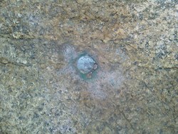
Description: Station mark is a Brass Plug Set in Bedrock, at nearly the highest point at the town dock on Branford Point Designation from the NOAA site is 846 5233 No stamping 1, Station is 63.5 FT WNW of the north end of the stone sea wall on the west side of the town
dock, 5.64 m (18.5 ft) west of the SE corner of an abandoned concrete
foundation, and 0.58 m (1.9 ft) SW of the SW corner of the foundation. Note:
mark is designated B-20 with the Branford Town Engineer.
Observed: 2016-12-08T14:41:00Z
Source: OPUS - page5 1209.04
Close-up View
REF_FRAME:   NAD_83(2011) EPOCH:   2010.0000 SOURCE:   NAVD88 (Computed using GEOID18) UNITS:  m  SET PROFILE   DETAILS
LAT: 41° 15' 38.69018" ±  0.003   m
LON: -72° 49' 16.15417" ±   0.004   m
ELL HT: -25.232 ±   0.010   m
X: 1418155.865 ±   0.003  m
Y: -4587316.316 ±   0.006  m
Z: 4184217.880 ±   0.009  m
ORTHO HT: 4.768 ±  0.055   m
UTM  18 SPC  600(CT )
NORTHING: 4569992.516m 199870.146m
EASTING: 682526.049m 298837.749m
CONVERGENCE: 1.43731625° -0.04717929°
POINT SCALE: 1.00001003 0.99999442
COMBINED FACTOR: 1.00001399 0.99999838
CONTRIBUTED BY
robert.d.benson
Connecticut Department of Transportation
Horizon View
The numerical values for this position solution have satisfied the quality control criteria of the National Geodetic Survey. The contributor has verified that the information submitted is accurate and complete.