| PID:
|
BBFM57 |
| Designation:
|
945 8519 B |
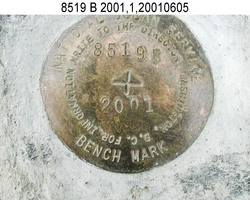
| Stamping:
|
8519 B 2001 |
| Stability:
|
Most reliable; expected to hold position well |
| Setting:
|
In rock outcrop or ledge |
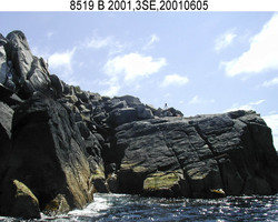
| Description:
|
The station is a disk set at the base of a rock outcrop with broken boulders protruding seaward, northwesterly of a boulder beach with the remains of a ship wreck, 1200 m (3937 ft) NE of bench mark 1 1925, 74.2 m (243.4 ft) ESE of the highest point on a group of rock islands awash at high tide, 16.14 m (53.0 ft) south of bench mark 8519 C 2001, 12.84 m (42.1 ft) NW of bench mark 8519 A 2001, and 8.4 m (27.6 ft) east of the most seaward point of the outcrop. |
| Observed:
|
2001-06-03T17:04:00Z |
| Source:
|
OPUS - page5 1209.04 |
|
|
|
| Close-up View
|
|
| REF_FRAME:
NAD_83(2011) |
EPOCH:
2010.0000 |
SOURCE:
NAVD88 (Computed using GEOID12B) |
UNITS:
m |
SET PROFILE
|
DETAILS
|
|
| LAT:
|
56° 3' 7.65150"
|
± 0.002
m |
| LON:
|
-156° 41' 53.59423"
|
±
0.009
m |
| ELL HT:
|
20.121 |
±
0.006
m |
| X:
|
-3278847.107 |
±
0.008
m |
| Y:
|
-1412215.372 |
±
0.007
m |
| Z:
|
5267702.162 |
±
0.004
m |
| ORTHO HT:
|
8.859 |
±
0.012
m |
|
|
UTM
4 |
SPC
5006(AK 6) |
| NORTHING:
|
6214270.171m |
229192.240m |
| EASTING:
|
643349.175m |
581101.537m |
| CONVERGENCE:
|
1.90975415°
|
1.07994414°
|
| POINT SCALE:
|
0.99985204 |
0.99998065 |
| COMBINED FACTOR:
|
0.99984889 |
0.99997750 |
|
|
|
|
| Horizon View
|
|
|
|
|